Image:ReliefUSA map.gif
Un article de Wikipédia, l'encyclopédie libre.
Pas de plus haute résolution disponible.
ReliefUSA_map.gif (714 × 496 pixels, taille du fichier : 228 Kio, type MIME : image/gif)
| | Ce fichier provient de Wikimedia Commons?. Les informations le concernant sont affichées ci-dessous (procédure). |
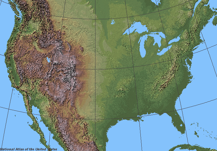
[edit] Description
Shaded relief in the lower 48 states of the United States of America.
[edit] License
| This map was obtained from an edition of the National Atlas of the United States. Like almost all works of the U.S. federal government, works from the National Atlas are in the public domain. Online access: NationalAtlas.gov | 1970 print edition: Library of Congress, Perry-Castañeda Library |
|
Historique du fichier
Cliquer sur une date et une heure pour voir le fichier tel qu’il était à ce moment-là
| Date et heure | Dimensions | Utilisateur | Commentaire | |
|---|---|---|---|---|
| actuel | 5 juin 2006 à 08:07 | 714×496 (228 Kio) | Urban | (==Description== Shaded relief in the lower 48 states of the United States of America. ==License== {{PD-USGov-Atlas}} ) |
Pages contenant l’image
Les pages ci-dessous contiennent cette image :
- Wikipédia:Wikiconcours/mars 2008/Équipes
- Discussion Wikipédia:Wikiconcours/mars 2008/Équipes/Équipe 10
- Discussion Wikipédia:Wikiconcours/mars 2008/Équipes/Équipe 10/Mammoth
- Discussion Wikipédia:Wikiconcours/mars 2008/Équipes/Équipe 10/Denver
- Discussion Wikipédia:Wikiconcours/mars 2008/Équipes/Équipe 10/Baltimore
- Discussion Wikipédia:Wikiconcours/mars 2008/Équipes/Équipe 10/Glacier
- Discussion Wikipédia:Wikiconcours/mars 2008/Équipes/Équipe 10/Modèle
- Discussion Wikipédia:Wikiconcours/mars 2008/Équipes/Équipe 10/Louisville

