Image:Yugoslaviamapfr.png
Un article de Wikipédia, l'encyclopédie libre.
Pas de plus haute résolution disponible.
Yugoslaviamapfr.png (330 × 355 pixels, taille du fichier : 181 Kio, type MIME : image/png)
| | Ce fichier provient de Wikimedia Commons?. Les informations le concernant sont affichées ci-dessous (procédure). |
| Description |
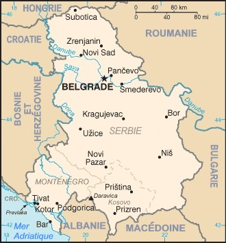
carte Serbie-et-Monténégro / map of The Federal Republic of Yugoslavia (Serbia and Montenegro) This is a map of The Federal Republic of Yugoslavia (Serbia and Montenegro) [FRY (S&M)] from as the 2000 CIA World Factbook as mirrored by the PCL. |
|---|---|
| Source | |
| Date | |
| Author | |
| Permission (Reusing this image) |
see below |
| This work is in the public domain in the United States because it is a work of the United States Federal Government under the terms of Title 17, Chapter 1, Section 105 of the US Code. See Copyright.
Note: This only applies to works of the Federal Government and not to the work of any individual U.S. state, territory, commonwealth, county, municipality, or any other subdivision. العربية | Български | Česky | Deutsch | English | Español | Français | Magyar | Italiano | 日本語 | 한국어 | Polski | Português | 中文(繁體) | 中文(简体) | +/- |
 |
| This image has been (or is hereby) released into the public domain by its author, Marc Liger at the French Wikipedia project. This applies worldwide. In case this is not legally possible: |
Historique du fichier
Cliquer sur une date et une heure pour voir le fichier tel qu’il était à ce moment-là
| Date et heure | Dimensions | Utilisateur | Commentaire | |
|---|---|---|---|---|
| actuel | 1 août 2007 à 10:10 | 330×355 (181 Kio) | ~Pyb | ({{Information |Description=carte Serbie-et-Monténégro / map of The Federal Republic of Yugoslavia (Serbia and Montenegro) |Source= fr:wp:Image:Yugoslaviamap.png |Date= |Author= fr:wp:User:Marc Liger |Permission= |other_versions= }} {{PD-use) |
Pages contenant l’image
La page ci-dessous contient cette image :

