Image:Usaf.e3sentry.750pix.jpg
Un article de Wikipédia, l'encyclopédie libre.
Taille de cet aperçu : 800 × 515 pixels
Image en plus haute résolution (1 243 × 800 pixels, taille du fichier : 81 Kio, type MIME : image/jpeg)
| | Ce fichier provient de Wikimedia Commons?. Les informations le concernant sont affichées ci-dessous (procédure). |
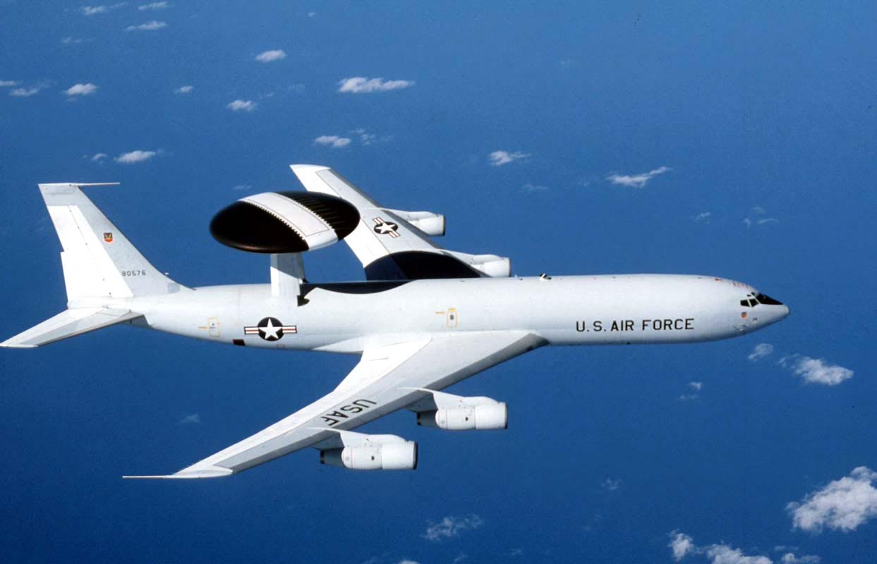
U.S. Air Force photograph of an E-3 Sentry
Source: http://www.af.mil/photos , [1]
| This image or file is a work of a U.S. Air Force Airman or employee, taken or made during the course of the person's official duties. As a work of the U.S. federal government, the image or file is in the public domain. |
 |
Historique du fichier
Cliquer sur une date et une heure pour voir le fichier tel qu’il était à ce moment-là
| Date et heure | Dimensions | Utilisateur | Commentaire | |
|---|---|---|---|---|
| actuel | 3 novembre 2007 à 15:07 | 1 243×800 (81 Kio) | Denniss | |
| 16 décembre 2005 à 13:08 | 750×483 (79 Kio) | WonYong | (U.S. Air Force photograph of the E-3 Sentry. By Gary Ell. {{PD-USGov-Military-Air Force}} [http://www.af.mil/photos] ) |
Pages contenant l’image
Les pages ci-dessous contiennent cette image :
Métadonnées
Ce fichier contient des informations supplémentaires probablement ajoutées par l’appareil photo numérique ou le numériseur qui l’a acquis. Si le fichier a été modifié depuis son état original, certains détails peuvent ne pas refléter entièrement l’image modifiée.
| Description de l’image | The E-3 Sentry is an airborne warning and control system (AWACS) aircraft that provides all-weather surveillance, command, control and communications needed by commanders of U.S. and NATO air defense forces. As proven in Desert Storm, it is the premier air battle command and control aircraft in the world today. The E-3 Sentry is a modified Boeing 707/320 commercial airframe with a rotating radar dome. The dome is 30 feet (9.1 meters) in diameter, six feet (1.8 meters) thick, and is held 11 feet (3.3 meters) above the fuselage by two struts. It contains a radar subsystem that permits surveillance fromthe Earth's surface up into the stratosphere, over land or water. The radar has a range of more than 200 miles (320 kilometers) for low-flying targets and farther for aerospace vehicles flying at medium to high altitudes. The radar combined with an identification friend or foe subsystem can look down to detect, identify and track enemy and friendly low-flying aircraft by eliminating ground clutter returns that confuse other radar systems. (U.S. Air Force photo) |
|---|---|
| Orientation | Normale |
| Résolution horizontale | 200 dpi |
| Résolution verticale | 200 dpi |
| Logiciel utilisé | Adobe Photoshop 7.0 |
| Date de modification | 26 novembre 2002 à 09:33 |
| Espace colorimétrique | 65535 |


![[1]](http://www.af.mil/shared/media/photodb/photos/021107-O-9999G-024.jpg)