Image:New Zealand map.PNG
Un article de Wikipédia, l'encyclopédie libre.
Pas de plus haute résolution disponible.
New_Zealand_map.PNG (323 × 590 pixels, taille du fichier : 89 Kio, type MIME : image/png)
| | Ce fichier provient de Wikimedia Commons?. Les informations le concernant sont affichées ci-dessous (procédure). |
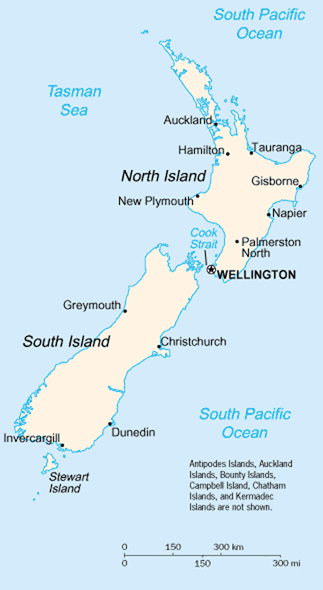
A map of New Zealand showing the major cities and towns. Not shown are the Antipodes Islands, Auckland Islands, Bounty Islands, Campbell Island, The Snares, and the Kermadec Islands.
https://www.cia.gov/library/publications/the-world-factbook/geos/nz.html
It should be noted that the scale on this map is not accurate. Measuring distances on the map then using the scale to determine those distances on the ground would lead to considerable exaggeration of those distances. This issue has been raised with the CIA, who compile these World Fact Book maps.
- Update - the latest version updated by Grutness is much better. Please see the Talk page for more.
| This image is in the public domain because it contains materials that originally came from the United States Central Intelligence Agency's World Factbook.
Deutsch | English | Español | Français | 日本語 | Nederlands | 한국어 | Português | தமிழ் | Magyar | +/- |
 |
Historique du fichier
Cliquer sur une date et une heure pour voir le fichier tel qu’il était à ce moment-là
| Date et heure | Dimensions | Utilisateur | Commentaire | |
|---|---|---|---|---|
| actuel | 30 juillet 2005 à 03:14 | 323×590 (89 Kio) | Grutness | (scale corrected) |
| 30 juillet 2005 à 03:04 | 323×590 (100 Kio) | Grutness | (Scale corrected) | |
| 6 mai 2005 à 06:24 | 323×590 (21 Kio) | Evil Monkey | (World Factbook map cropped and modified but still PD) |
Pages contenant l’image
Les pages ci-dessous contiennent cette image :

