Image:Mt st helens cendres.png
Un article de Wikipédia, l'encyclopédie libre.
Taille de cet aperçu : 800 × 564 pixels
Image en plus haute résolution (820 × 578 pixels, taille du fichier : 110 Kio, type MIME : image/png)
| | Ce fichier provient de Wikimedia Commons?. Les informations le concernant sont affichées ci-dessous (procédure). |
| Description |
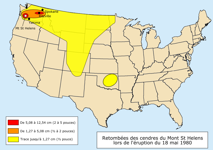
Français :
Retombées des cendres de l'éruption du Mont St Helens le 18 mai 1980.
English:
Distribution of ash following the eruption of Mount St Helens on May 18, 1980. |
|---|---|
| Source |
Image:1980 St. Helens ashmap.png by USGS |
| Date |
7 April 2006 |
| Author |
historicair 22:32, 7 April 2006 (UTC) |
| Permission (Reusing this image) |
|

English: This map was made or improved by the Wikigraphists of the Atelier graphique. You can propose maps or images to clean up and improve as well.
Esperanto: Ĉi tiu mapo estis kreita aŭ plibonigita de la Vikigrafistoj el la Grafika laborgrupo. Vi ankaŭ povas tie proponi mapojn aŭ bildojn plibonigendajn.
Español: Este mapa ha sido confeccionado o mejorado por los Wikígrafos del Taller gráfico. Puedes proponer la mejora de cualquier imagen a través de la página de Peticiones.
Français : Cette carte a été créée ou améliorée par les Wikigraphistes de l'Atelier graphique. Vous pouvez également y proposer des cartes ou des images à améliorer.
Türkçe: Bu harita Atelier graphique'ten Wikigraphistes'ler tarafından yapıldı veya geliştirildi. Siz de haritalar veya resimleri temizlemek veya geliştirmek için teklif edebilirsiniz.
Historique du fichier
Cliquer sur une date et une heure pour voir le fichier tel qu’il était à ce moment-là
| Date et heure | Dimensions | Utilisateur | Commentaire | |
|---|---|---|---|---|
| actuel | 8 avril 2006 à 18:53 | 820×578 (110 Kio) | Historicair | |
| 8 avril 2006 à 00:32 | 820×578 (110 Kio) | Historicair | (Retombées des cendres de l'éruption du Mont St Helens le 18 mai 1980. D'après (Image:1980 St. Helens ashmap.png) Retravaillé par ~~~~ {{Atelier graphique}} Category:Mount St. Helens) |
Pages contenant l’image
Les pages ci-dessous contiennent cette image :

