Image:Mongol Empire map 2.gif
Un article de Wikipédia, l'encyclopédie libre.
Pas de plus haute résolution disponible.
Mongol_Empire_map_2.gif (752 × 591 pixels, taille du fichier : 58 Kio, type MIME : image/gif)
| | Ce fichier provient de Wikimedia Commons?. Les informations le concernant sont affichées ci-dessous (procédure). |
[edit] Summary
| Description |
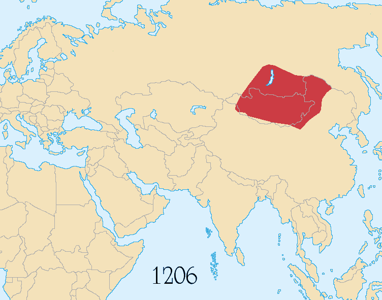
Map showing changes in borders of the Mongol Empire from founding by Genghis Khan in 1206, Genghis Khan's death in 1227 to the rule of Kublai Khan (1260–1294). (Uses modern day borders) ██ Mongol Empire By 1294 the empire had split into: ██ Golden Horde ██ Ilkhanate ██ Yuan Dynasty (Great Khanate) |
|---|---|
| Source |
Based on the freely licenced Image:Genghis khan empire at his death.png using information from maps of the Mongol Empire in atlases and on the web such as [1], [2], [3], [4], [5]. Made in Photoshop and Painter. |
| Date |
June 2006, modified October 2006 and May 2008 |
| Author |
User:Astrokey44, modified by Sting and Wengier |
| Permission (Reusing this image) |
GFDL / CC-by-sa-2.5,2.0,1.0 |
| Other versions | other maps on commons - original animation but with alternative colours, greatest extent, Mongol dominions, 1294 |
[edit] Licensing

| This file is licensed under the Creative Commons Attribution ShareAlike license versions 2.5, 2.0, and 1.0
العربية | Български | Català | Česky | Dansk | Deutsch | English | Español | Euskara | فارسی | Français | עברית | Italiano | 日本語 | 한국어 | Lietuvių | Nederlands | Polski | Português | Русский | Svenska | தமிழ் | Türkçe | 中文 | 中文 | +/- |
Historique du fichier
Cliquer sur une date et une heure pour voir le fichier tel qu’il était à ce moment-là
| Date et heure | Dimensions | Utilisateur | Commentaire | |
|---|---|---|---|---|
| actuel | 1 juin 2008 à 01:40 | 752×591 (58 Kio) | Wengier | ({{Information |Description=add "1279" tag |Source=previous version |Date= |Author= |Permission= |other_versions= }}) |
| 1 juin 2008 à 01:24 | 752×591 (59 Kio) | Wengier | ({{Information |Description=small fixes |Source=based on original version |Date= |Author= |Permission= |other_versions= }}) | |
| 22 octobre 2006 à 18:17 | 752×591 (58 Kio) | Sting | ({{Information |Description= Map showing changes in borders of the Mongol Empire from founding by Genghis Khan in 1206, Genghis Khan's death in 1227 to the rule of Kublai Khan (1260–1294). (Uses mo) |
Pages contenant l’image
Les pages ci-dessous contiennent cette image :


![[1]](http://www.silk-road.com/maps/images/mongol.jpg)
![[2]](http://www.loyno.edu/~seduffy/MapImages/MongolEmpire-display.jpg)
![[3]](http://www.siu.edu/~dfll/Chinese/mongol.jpg)
![[4]](http://www.allempires.com/empires/mongol/mongolempire_map.jpg)
![[5]](http://www.tiscali.co.uk/reference/encyclopaedia/hutchinson/images/c01786.jpg)