Image:Faciliteitengemeenten.png
Un article de Wikipédia, l'encyclopédie libre.
Pas de plus haute résolution disponible.
Faciliteitengemeenten.png (405 × 333 pixels, taille du fichier : 6 Kio, type MIME : image/png)
| | Ce fichier provient de Wikimedia Commons?. Les informations le concernant sont affichées ci-dessous (procédure). |
[edit] Summary
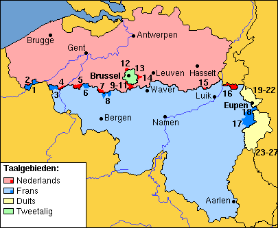
Map of Belgian municipalities with language facilities, with large cities marked with their Dutch names; based on Image:Comunidades lingüísticas de Bélgica.png.
Legend (official names first, names in minority language between brackets):
- 1 = Comines-Warneton (Komen-Waasten)
- 2 = Mesen (Messines)
- 3 = Mouscron (Moeskroen)
- 4 = Spiere-Helkijn (Espierres-Helchin)
- 5 = Ronse (Renaix)
- 6 = Flobecq (Vloesberg)
- 7 = Bever (Biévène)
- 8 = Enghien (Edingen)
- 9 = Drogenbos
- 10 = Linkebeek
- 11 = Sint-Genesius-Rode (Rhode-Saint-Genèse)
- 12 = Wemmel
- 13 = Kraainem
- 14 = Wezembeek-Oppem
- 15 = Herstappe
- 16 = Voeren (Fourons)
- 17 = Malmédy (Malmund)
- 18 = Waimes
- 19-22 = Lontzen, Raeren, Eupen, Kelmis (La Calamine)
- 23-27 = Burg-Reuland, Sankt Vith (Saint-Vith), Amel (Amblève), Bütgenbach, Büllingen (Bullange)
 |
This map image should be recreated using vector graphics as an SVG file. This has several advantages; see Commons:Media for cleanup for more information. If an SVG form of this image is already available, please upload it. After uploading an SVG, replace this template with template {{Vector version available|new image name.svg}} in this image. |
|
العربية | Български | Català | Česky | Dansk | Deutsch | English | Esperanto | Español | Français | 한국어 | Italiano | Magyar | Lietuvių | Nederlands | 日本語 | Polski | Português | Română | Русский | Suomi | Svenska | Türkçe | Українська | Tiếng Việt | मराठी | 中文(繁體) | 中文(简体) | +/- |
|
[edit] Licensing

Historique du fichier
Cliquer sur une date et une heure pour voir le fichier tel qu’il était à ce moment-là
| Date et heure | Dimensions | Utilisateur | Commentaire | |
|---|---|---|---|---|
| actuel | 27 août 2006 à 19:22 | 405×333 (6 Kio) | Gpvos | (Map of Belgian municipalities with language facilities, with Dutch labels; based on Image:Comunidades lingüísticas de Bélgica.png) |
Pages contenant l’image
La page ci-dessous contient cette image :

