Image:VietnameseRegions.png
Un article de Wikipédia, l'encyclopédie libre.
Pas de plus haute résolution disponible.
VietnameseRegions.png (300 × 443 pixels, taille du fichier : 40 Kio, type MIME : image/png)
| | Ce fichier provient de Wikimedia Commons?. Les informations le concernant sont affichées ci-dessous (procédure). |
[edit] Description
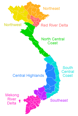
Labeled map of the regions in Vietnam classified by General Satistics Office of Vietnam since 1999.
[edit] License

, created by uploader.
Historique du fichier
Cliquer sur une date et une heure pour voir le fichier tel qu’il était à ce moment-là
| Date et heure | Dimensions | Utilisateur | Commentaire | |
|---|---|---|---|---|
| actuel | 28 janvier 2008 à 03:38 | 300×443 (40 Kio) | Binh Giang | (Reverted to version as of 23:06, 20 January 2006) |
| 9 octobre 2007 à 12:50 | 300×443 (39 Kio) | Sl | (Change Vĩnh Phúc Province into the colour of Đông Bắc) | |
| 21 janvier 2006 à 01:06 | 300×443 (40 Kio) | Vardion | (correcting boundary between Dien Bien and Lai Chau provinces) | |
| 13 juin 2005 à 00:09 | 241×357 (26 Kio) | Vardion | (Labeled map of the regions that Vietnam often seems to divide its provinces into. Don't know what their official status is. {{GFDL}}, created by uploader.) |
Pages contenant l’image
Les pages ci-dessous contiennent cette image :

