Image:United States 1817-03-1817-12.png
Un article de Wikipédia, l'encyclopédie libre.
Taille de cet aperçu : 800 × 542 pixels
Image en plus haute résolution (1 000 × 677 pixels, taille du fichier : 114 Kio, type MIME : image/png)
| | Ce fichier provient de Wikimedia Commons?. Les informations le concernant sont affichées ci-dessous (procédure). |
[edit] Summary
[edit] Summary
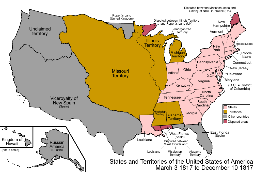
| Description |
Map of the states and territories of the United States as it was from March 1817 to December 1817. On March 3 1817, Alabama Territory was split from Mississppi Territory. On December 10 1817, Mississippi Territory was admitted as the state of Mississippi. |
|---|---|
| Source | No source specified. Please edit this image description and provide a source. |
| Date | |
| Author |
Made by User:Golbez. |
| Permission (Reusing this image) |
Own work, attribution required (Multi-license with GFDL and Creative Commons CC-BY 2.5) |
[edit] Licensing
|

| Territorial evolution maps of the United States |
| v · d (template shows date of beginning of change yyyy-mm-dd) |
| 1789-03, 1789-08, 1790-04, 1790-05, 1791-03, 1791-09, 1792-03, 1792-06, 1795, 1796, 1798, 1800-07-04, 1800-07, 1802, 1803-03, 1803-04, 1804-03, 1804-10, 1805-01, 1805-07, 1809, 1810-04, 1810-10, 1812-04, 1812-05, 1812-06, 1816, 1817-03, 1817-12, 1818-10, 1818-12, 1819-03, 1819-12, 1820, 1821-07, 1821, 1822, 1824, 1828, 1834, 1836-03, 1836-06, 1836-07, 1837-01, 1837-03, 1838, 1842, 1845-03, 1845-12, 1846-06, 1846-12, 1848-02, 1848-05, 1848-08, 1849, 1850, 1853-03, 1853-12, 1854, 1858, 1859, 1860, 1861-01, 1861-02-04, 1861-02-28, 1861-03, 1861-08, 1862, 1863-02, 1863-03, 1863-06, 1864-05, 1864-10, 1865, 1866, 1867-01, 1867-03, 1867-10, 1868, 1876, 1884, 1889-11-02, 1889-11-08, 1889-11-11, 1890-05, 1890-07-03, 1890-07-10, 1896-01, 1896-05, 1898, 1907, 1912-01, 1912-02, 1912-08, 1959-01, 1959-08 |
Historique du fichier
Cliquer sur une date et une heure pour voir le fichier tel qu’il était à ce moment-là
| Date et heure | Dimensions | Utilisateur | Commentaire | |
|---|---|---|---|---|
| actuel | 1 août 2007 à 13:25 | 1 000×677 (114 Kio) | Golbez | |
| 1 août 2007 à 12:47 | 1 000×677 (111 Kio) | Golbez |
Pages contenant l’image
La page ci-dessous contient cette image :

