Image:Tephra fall from 1991 eruption of Mt Pinatubo fr.gif
Un article de Wikipédia, l'encyclopédie libre.

Pas de plus haute résolution disponible.
Tephra_fall_from_1991_eruption_of_Mt_Pinatubo_fr.gif (600 × 425 pixels, taille du fichier : 27 Kio, type MIME : image/gif)
| | Ce fichier provient de Wikimedia Commons?. Les informations le concernant sont affichées ci-dessous (procédure). |
| Description |
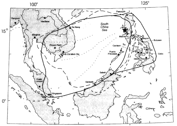
Area over which tephra from 1991 eruption of Mt Pinatubo fell. English: This map was made or improved by the Wikigraphists of the Atelier graphique. You can propose maps or images to clean up and improve as well.
Esperanto: Ĉi tiu mapo estis kreita aŭ plibonigita de la Vikigrafistoj el la Grafika laborgrupo. Vi ankaŭ povas tie proponi mapojn aŭ bildojn plibonigendajn.
Español: Este mapa ha sido confeccionado o mejorado por los Wikígrafos del Taller gráfico. Puedes proponer la mejora de cualquier imagen a través de la página de Peticiones.
Français : Cette carte a été créée ou améliorée par les Wikigraphistes de l'Atelier graphique. Vous pouvez également y proposer des cartes ou des images à améliorer.
Türkçe: Bu harita Atelier graphique'ten Wikigraphistes'ler tarafından yapıldı veya geliştirildi. Siz de haritalar veya resimleri temizlemek veya geliştirmek için teklif edebilirsiniz.
|
|---|---|
| Source |
fr:Image:Tephra fall from 1991 eruption of Mt Pinatubo.gif Fig.9 on [1]. |
| Date | |
| Author | |
| Permission (Reusing this image) |
see below |
| This image is in the public domain because it contains materials that originally came from the United States Geological Survey, an agency of the United States Department of Interior. For more information, see the official USGS copyright policy |
|
Historique du fichier
Cliquer sur une date et une heure pour voir le fichier tel qu’il était à ce moment-là
| Date et heure | Dimensions | Utilisateur | Commentaire | |
|---|---|---|---|---|
| actuel | 2 août 2007 à 21:56 | 600×425 (27 Kio) | ~Pyb | ({{Information |Description=Area over which tephra from 1991 eruption of Mt Pinatubo fell. {{Atelier graphique carte}} |Source= [http://pubs.usgs.gov/pinatubo/paladio/fig9.gif Fig.9] on [http://pubs.usgs.gov/pinatubo/paladio]. |Date= |Author= [[:fr:User:) |
Pages contenant l’image
Les pages ci-dessous contiennent cette image :

