Image:Sierra Nevada map.png
Un article de Wikipédia, l'encyclopédie libre.
Pas de plus haute résolution disponible.
Sierra_Nevada_map.png (278 × 315 pixels, taille du fichier : 5 Kio, type MIME : image/png)
| | Ce fichier provient de Wikimedia Commons?. Les informations le concernant sont affichées ci-dessous (procédure). |
[edit] Summary
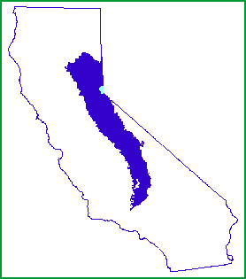
| Description |
Map of the Sierra Nevada, United States |
|---|---|
| Source | |
| Date |
1999-07-12 |
| Author |
John W. Dale, U.S. Forest Service |
| Permission (Reusing this image) |
Public Domain |
[edit] Licensing
| This image is a work of a United States Department of Agriculture employee, taken or made during the course of the person's official duties. As a work of the U.S. federal government, the image is in the public domain. |
Historique du fichier
Cliquer sur une date et une heure pour voir le fichier tel qu’il était à ce moment-là
| Date et heure | Dimensions | Utilisateur | Commentaire | |
|---|---|---|---|---|
| actuel | 8 janvier 2007 à 01:21 | 278×315 (5 Kio) | Hike395 | ({{Information |Description=Map of the Sierra Nevada, United States |Source=http://www.fs.fed.us/r5/spf/publications/fh_94-95/m261e.htm |Date=1999-07-12 |Author=John W. Dale, U.S. Forest Service |Permission=Public Domain }}) |
Pages contenant l’image
La page ci-dessous contient cette image :

