Image:Scandinavia.TMO2003050.jpg
Un article de Wikipédia, l'encyclopédie libre.
Taille de cet aperçu : 466 × 599 pixels
Image en plus haute résolution (5 600 × 7 200 pixels, taille du fichier : 7,42 Mio, type MIME : image/jpeg)
| | Ce fichier provient de Wikimedia Commons?. Les informations le concernant sont affichées ci-dessous (procédure). |
|
|
This file was a candidate on Picture of the Year 2006. This is a featured picture on Wikimedia Commons: it is considered one of our finest images. This is a featured picture on German Wikipedia and is considered one of the finest images. This is a featured picture on Turkish Wikipedia and is considered one of the finest images. If you have an image of similar quality that can be published under a suitable copyright license, be sure to upload it, tag it, and nominate it. |
| Description |
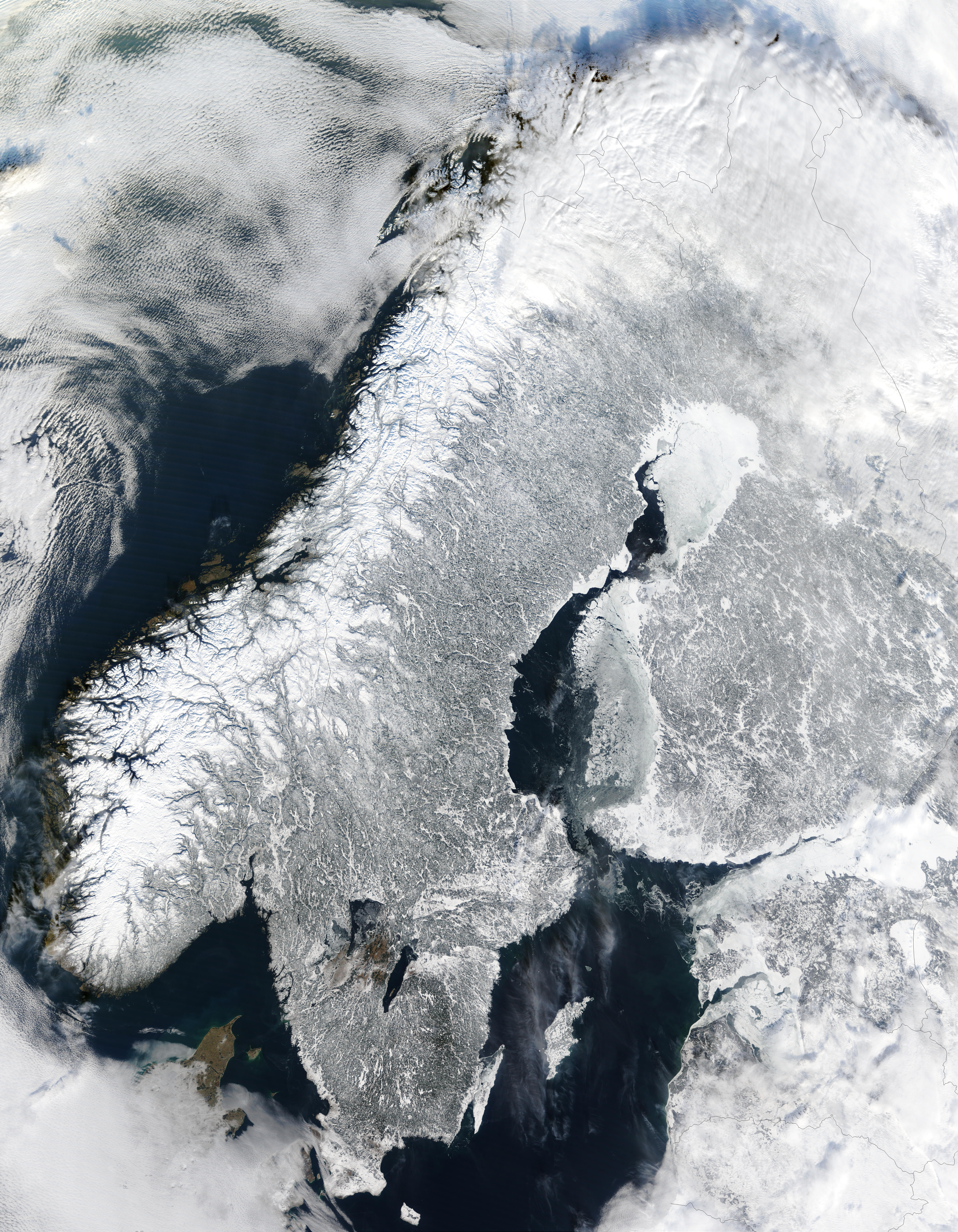
English: Scandinavia from space in winter.
The Moderate Resolution Imaging Spectroradiometer (MODIS) instrument aboard NASA’s Terra satellite captured the above image of the Scandinavian Peninsula on February 19, 2003. Español: Escandinavia en invierno, imagen de la NASA
Français : Scandinavie en hiver depuis l'espace. Image prise par l'instrument MODIS à bord du satellite Terra de la NASA.
Avec ses paysages sculptés par les glaciers du quaternaire, la Scandinavie en hiver est aussi pittoresque que froide. A l'ouest sont visibles les étroits bras de mer appelés fjords, qui ponctuent la côte norvégienne. Ces fjords très profonds (plus de 600 m et jusque 1308m dans le Sognefjord) ont étés creusés par de lourds glaciers au cours des âges glaciaires. Ces glaciers descendus de la montagne ont creusé leurs vallées bien en dessous du niveau de la mer. A la fin de la glaciation, c'est donc la mer qui a envahis ces profondes vallées. Nederlands: Satellietopname van Noorwegen, Zweden en Finland in de winter
Русский: Скандинавский полуостров зимой (19 февраля 2003)
Svenska: Satellitbild över Skandinavien. Hela halvön är täckt av snö.
|
|---|---|
| Source | |
| Date |
photo taken 19. Feb. 2003 |
| Author |
Jacques Descloitres, MODIS Land Rapid Response Team at NASA GSFC |
| Permission (Reusing this image) |
Quote of http://rapidfire.sci.gsfc.nasa.gov/faq/ - All the images that appear on our site are in the public domain and can be freely used and reproduced for any purpose. Please credit the MODIS Rapid Response Project appropriately: "Image courtesy of MODIS Rapid Response Project at NASA/GSFC". |
|
|
This file is in the public domain because it was created by NASA. NASA copyright policy states that "NASA material is not protected by copyright unless noted". (NASA copyright policy page or JPL Image Use Policy).
Deutsch | English | Español | Français | Nederlands | Português | Русский | 中文(简体) | 中文(繁體) | +/- |
|
 |
Warnings:
|
| This image was selected as a picture of the day for January 12, 2005. It was captioned as followed:
English: Scandinavia from space in winter.
Česky: Zimní Skandinávie při pohledu z vesmíru
Deutsch: Winterliches Skandinavien aus dem Weltraum gesehen
English: Scandinavia from space in winter.
Esperanto: Skandinavio de spaco vintre.
Español: La Península Escandinava en invierno vista desde el espacio
Suomi: Kuva talvisesta Fenno-Skandiasta ja Baltiasta avaruudesta kuvattuna
Français : Vue depuis orbite terrestre de la péninsule scandinave en hiver.
Italiano: Vista della Scandinavia innevata dallo spazio.
日本語: スカンジナビアの衛星写真
Nederlands: Satellietfoto van Scandinavië in de winter
Português: Escandinávia vista do espaço no inverno.
Română: Scandinavia din spaţiu, iarna
Svenska: Satellitbild på ett vintrigt Skandinavien
|
Historique du fichier
Cliquer sur une date et une heure pour voir le fichier tel qu’il était à ce moment-là
| Date et heure | Dimensions | Utilisateur | Commentaire | |
|---|---|---|---|---|
| actuel | 2 janvier 2005 à 05:06 | 5 600×7 200 (7,42 Mio) | Ed g2s | (larger) |
| 21 décembre 2004 à 02:56 | 540×611 (127 Kio) | Mschlindwein | (Scandinavia from space in winter) |
Pages contenant l’image
Les pages ci-dessous contiennent cette image :

