Image:Satellite Lanzarote Chinijo.jpg
Un article de Wikipédia, l'encyclopédie libre.
Pas de plus haute résolution disponible.
Satellite_Lanzarote_Chinijo.jpg (422 × 253 pixels, taille du fichier : 30 Kio, type MIME : image/jpeg)
| | Ce fichier provient de Wikimedia Commons?. Les informations le concernant sont affichées ci-dessous (procédure). |
[edit] Summary
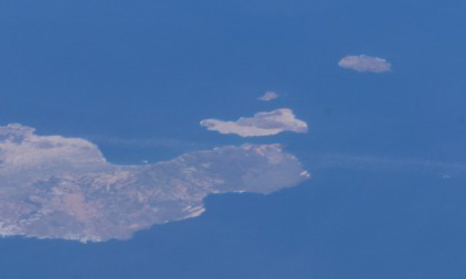
Español: De abajo a arriba, Lanzarote, La Graciosa, Montaña Clara y Alegranza
Satellite photo showing Lanzarote and Chinijo Archipielago. From bottom to top, Lanzarote, La Graciosa, Montaña Clara y Alegranza.
|
|
This file is in the public domain because it was created by NASA. NASA copyright policy states that "NASA material is not protected by copyright unless noted". (NASA copyright policy page or JPL Image Use Policy).
Deutsch | English | Español | Français | Nederlands | Português | Русский | 中文(简体) | 中文(繁體) | +/- |
|
 |
Warnings:
|
[edit] Source
Image courtesy of the Image Analysis Laboratory, NASA Johnson Space Center.
Historique du fichier
Cliquer sur une date et une heure pour voir le fichier tel qu’il était à ce moment-là
| Date et heure | Dimensions | Utilisateur | Commentaire | |
|---|---|---|---|---|
| actuel | 25 juin 2005 à 09:05 | 422×253 (30 Kio) | Porao | (Imagen de satélite de Lanzarote y el Archipiélago Chinijo. De abajo a arriba, Lanzarote, La Graciosa, Montaña Clara y Alegranza.) |
Pages contenant l’image
La page ci-dessous contient cette image :
Métadonnées
Ce fichier contient des informations supplémentaires probablement ajoutées par l’appareil photo numérique ou le numériseur qui l’a acquis. Si le fichier a été modifié depuis son état original, certains détails peuvent ne pas refléter entièrement l’image modifiée.
| Orientation | Normale |
|---|---|
| Résolution horizontale | 72 dpi |
| Résolution verticale | 72 dpi |
| Logiciel utilisé | Adobe Photoshop CS Windows |
| Date de modification | 25 juin 2005 à 09:02 |
| Espace colorimétrique | sRGB |

