Image:Rome against Taranto location-fr.png
Un article de Wikipédia, l'encyclopédie libre.
Pas de plus haute résolution disponible.
Rome_against_Taranto_location-fr.png (253 × 240 pixels, taille du fichier : 26 Kio, type MIME : image/png)
| | Ce fichier provient de Wikimedia Commons?. Les informations le concernant sont affichées ci-dessous (procédure). |
[edit] Summary
| Description |
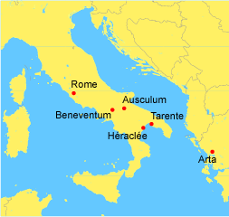
Map in French of the wars between Rome and Taranto |
|---|---|
| Source |
Image:Rome_against_Taranto_location.png created by en:User:Panairjdde |
| Date |
May 2005 (original) |
| Author |
of the translation :Sting |
| Permission (Reusing this image) |
GFDL |
| Other versions | Original English version : Image:Rome_against_Taranto_location.png |
Complementary data :
- Roma
- Beneventum (mod. Benevento) - battle of Beneventum (275 BC)
- Asculum (mod. Ascoli Satriano) - battle of Asculum (279 BC)
- Heraclea - battle of Heraclea (280 BC)
- Tarentum
- Arta - capital of Epirus kingdom
Français :
- Sujet : Carte en français des guerres entre Rome et Tarente ;
- Fond de carte : Image:Rome_against_Taranto_location.png créée par en:User:Panairjdde ;
- Autres versions disponibles :
-
- anglophone : Image:Rome_against_Taranto_location.png
- Traduction : fr:Sting ;
- Dates : Mai 2005 (originale) - Août 2006 (traduction).
English: This map was made or improved by the Wikigraphists of the Atelier graphique. You can propose maps or images to clean up and improve as well.
Esperanto: Ĉi tiu mapo estis kreita aŭ plibonigita de la Vikigrafistoj el la Grafika laborgrupo. Vi ankaŭ povas tie proponi mapojn aŭ bildojn plibonigendajn.
Español: Este mapa ha sido confeccionado o mejorado por los Wikígrafos del Taller gráfico. Puedes proponer la mejora de cualquier imagen a través de la página de Peticiones.
Français : Cette carte a été créée ou améliorée par les Wikigraphistes de l'Atelier graphique. Vous pouvez également y proposer des cartes ou des images à améliorer.
Türkçe: Bu harita Atelier graphique'ten Wikigraphistes'ler tarafından yapıldı veya geliştirildi. Siz de haritalar veya resimleri temizlemek veya geliştirmek için teklif edebilirsiniz.
[edit] Licensing

Historique du fichier
Cliquer sur une date et une heure pour voir le fichier tel qu’il était à ce moment-là
| Date et heure | Dimensions | Utilisateur | Commentaire | |
|---|---|---|---|---|
| actuel | 29 août 2006 à 23:39 | 253×240 (26 Kio) | Sting | ({{Information |Description=Map in French of the wars between Rome and Taranto |Source=Image:Rome_against_Taranto_location.png created by en:User:Panairjdde |Date=May 2005 (original)<br/>August 2006 (translation) |Author=of the translation :[[Use) |
Pages contenant l’image
Les pages ci-dessous contiennent cette image :

