Image:Quad Flandria.jpg
Un article de Wikipédia, l'encyclopédie libre.
Taille de cet aperçu : 800 × 597 pixels
Image en plus haute résolution (3 345 × 2 498 pixels, taille du fichier : 7,53 Mio, type MIME : image/jpeg)
| | Ce fichier provient de Wikimedia Commons?. Les informations le concernant sont affichées ci-dessous (procédure). |
|
|
This is a featured picture on Wikimedia Commons: it is considered one of our finest images. If you have an image of similar quality that can be published under a suitable copyright license, be sure to upload it, tag it, and nominate it. |
| This image was selected as a picture of the day for May 06, 2008. It was captioned as followed:
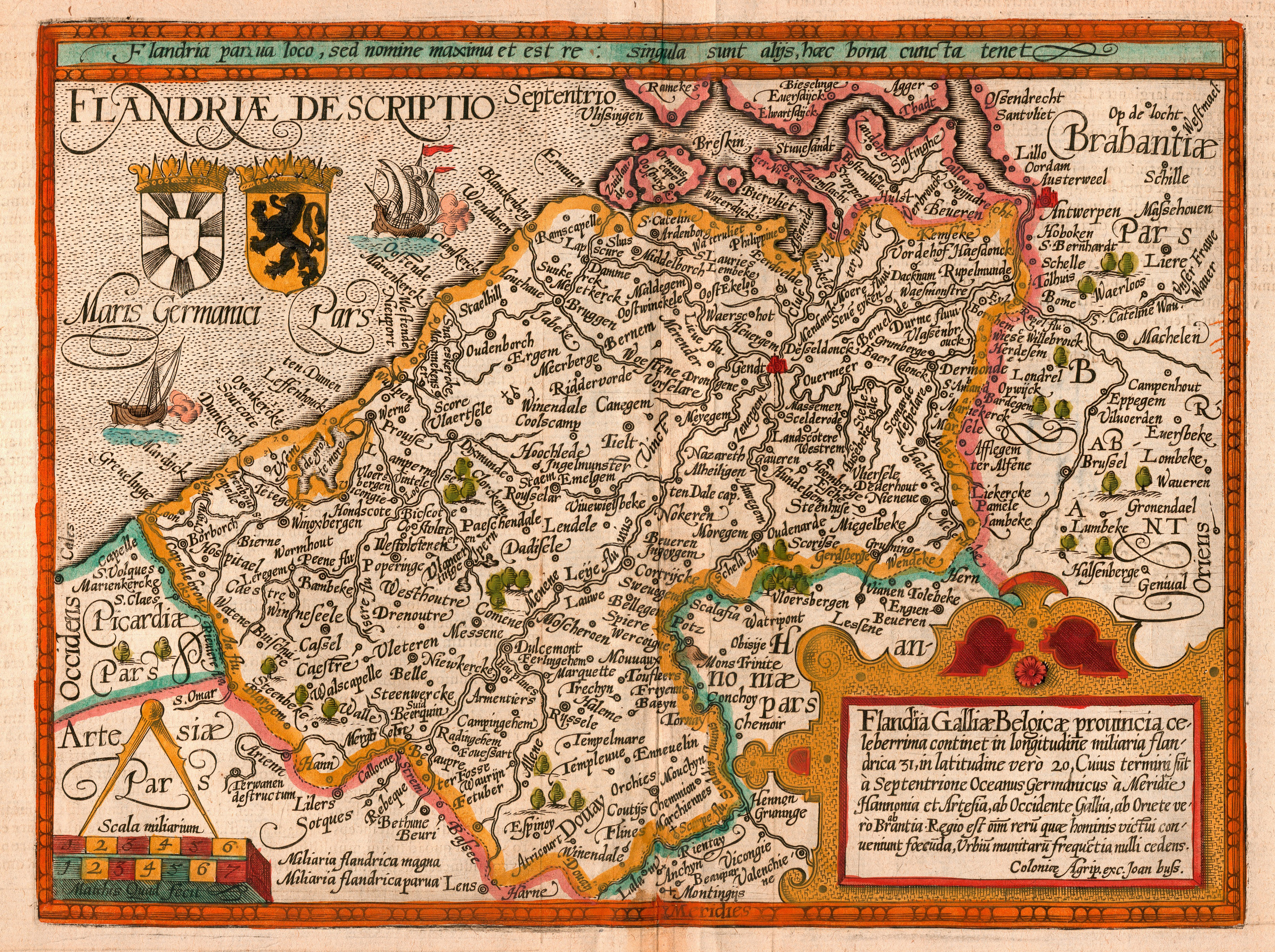
English: Map of the county of Flanders by 1609
Alemannisch: Charte vo Flandern (Belgiä) us em Jahr 1609.
العربية: خريطة دولة فلندرز عام 1609.
Беларуская: Карта Фландрыі (1609)
Česky: Mapa Vévodství Flandry z roku 1609
Dansk: Kort over Flandern (Belgien) i 1609.
Deutsch: Karte von Flandern (Belgien) aus dem Jahre 1609.
English: Map of the county of Flanders by 1609
Français : Carte de la flandre
Magyar: Flandria térképe 1609-ből, Matthias Quad térképész és Johannes Bussemacher grafikus és kiadó (Köln) munkája
Íslenska: Kort af Flandri árið 1609.
Italiano: Mappa delle Fiandre del 1609.
日本語: 1609年のフランドル地域の地図
한국어: 1609년에 그려진 플란데런 지도.
Русский: Карта Фландрии 1609 года
Српски / Srpski: Мапа Фландрије из 1609. године.
Svenska: Grevskapet Flandern på en karta från 1609.
Türkçe: Flanders kontluğunun 1609'daki haritası
Українська: Карта Фландрії 1609 року
中文(简体): 佛兰德伯国1609年地图
中文(繁體): 佛蘭德伯國1609年地圖
|
[edit] Samenvatting
| Description |
English: Map of the county of Flanders by Matthias Quad (cartographer) and Johannes Bussemacher (engraver & publisher, Cologne)
Nederlands: Kaart van het graafschap Vlaanderen door Matthias Quad (kartograaf) en Johannes Bussemacher (graveur en uitgever, Keulen)
Français : Carte du comté de Flandre par Matthias Quad (cartographe) et Johannes Bussemacher (graveur et éditeur, Cologne)
Español: Mapa del condado de Flandes, de Matthias Quad (cartógrafo) y Johannes Bussemacher (grabador y editor, Colonia, Alemania)
|
|---|---|
| Source |
eigen werk (scan) |
| Date |
1609 |
| Author |
Matthias Quad (†1613) and Johannes Bussemacher / scanned by Marc Ryckaert (MJJR) |
| Permission (Reusing this image) |
see below |
[edit] Licensing
| This image (or other media file) is in the public domain because its copyright has expired. This applies to the United States, Canada, the European Union and those countries with a copyright term of life of the author plus 70 years.
العربية | Asturianu | Български | Català | Česky | Dansk | Deutsch | English | Ελληνικά | Esperanto | Español | Euskara | فارسی | Français | Gaeilge | Galego | עברית | हिन्दी | Bahasa Indonesia | Italiano | 日本語 | 한국어 | Kurdî / كوردی | Lietuvių | Magyar | Nederlands | Norsk (nynorsk) | Македонски | Bahasa Melayu | Polski | Português | Română | Русский | Slovenčina | Slovenščina | Shqip | Suomi | Sámegiella | Türkçe | 中文(简体) | 中文(繁體) | 粵語 | +/- |
Historique du fichier
Cliquer sur une date et une heure pour voir le fichier tel qu’il était à ce moment-là
| Date et heure | Dimensions | Utilisateur | Commentaire | |
|---|---|---|---|---|
| actuel | 19 février 2008 à 22:26 | 3 345×2 498 (7,53 Mio) | MJJR | ({{Information |Description= {{en|Map of the county of Flanders by Matthias Quad (cartographer) and Johannes Bussemacher (engraver & publisher, Cologne)}} {{nl|Kaart van het graafschap Vlaanderen door Matthias Quad (kartograaf) en Johannes Bussemacher (gra) |
| 17 février 2008 à 23:52 | 3 345×2 498 (7,47 Mio) | MJJR | ({{Information |Description= {{en|Map of the county of Flanders by Matthias Quad (cartographer) and Johannes Bussemacher (engraver & publisher, Cologne)}} {{nl|Kaart van het graafschap Vlaanderen door Matthias Quad (kartograaf) en Johannes Bussemacher (gra) |
Pages contenant l’image
Les pages ci-dessous contiennent cette image :
Métadonnées
Ce fichier contient des informations supplémentaires probablement ajoutées par l’appareil photo numérique ou le numériseur qui l’a acquis. Si le fichier a été modifié depuis son état original, certains détails peuvent ne pas refléter entièrement l’image modifiée.
| Orientation | Normale |
|---|---|
| Résolution horizontale | 300 dpi |
| Résolution verticale | 300 dpi |
| Logiciel utilisé | Adobe Photoshop 7.0 |
| Date de modification | 19 février 2008 à 21:18 |
| Espace colorimétrique | 65535 |

