Image:Punjab 1903.gif
Un article de Wikipédia, l'encyclopédie libre.
Pas de plus haute résolution disponible.
Punjab_1903.gif (640 × 480 pixels, taille du fichier : 338 Kio, type MIME : image/gif)
| | Ce fichier provient de Wikimedia Commons?. Les informations le concernant sont affichées ci-dessous (procédure). |
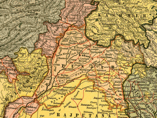
In this map, the British Raj Punjab province is colored pink, and the Indian princely states are colored yellow. As the map indicates, a number of princely states, mostly in the eastern Punjab, fell under the political authority of the British Governor of the Punjab. From map of India by Dodd, Mead and Company, 1903. Library of Congress Geography and Map Collection. Call Number G7650 1903 .D6 TIL
| This image (or other media file) is in the public domain because its copyright has expired. This applies to the United States, Canada, the European Union and those countries with a copyright term of life of the author plus 70 years.
العربية | Asturianu | Български | Català | Česky | Dansk | Deutsch | English | Ελληνικά | Esperanto | Español | Euskara | فارسی | Français | Gaeilge | Galego | עברית | हिन्दी | Bahasa Indonesia | Italiano | 日本語 | 한국어 | Kurdî / كوردی | Lietuvių | Magyar | Nederlands | Norsk (nynorsk) | Македонски | Bahasa Melayu | Polski | Português | Română | Русский | Slovenčina | Slovenščina | Shqip | Suomi | Sámegiella | Türkçe | 中文(简体) | 中文(繁體) | 粵語 | +/- |
Historique du fichier
Cliquer sur une date et une heure pour voir le fichier tel qu’il était à ce moment-là
| Date et heure | Dimensions | Utilisateur | Commentaire | |
|---|---|---|---|---|
| actuel | 6 mai 2005 à 14:54 | 640×480 (338 Kio) | Shauni | (In this map, the British Raj Punjab province is colored pink, and the Indian princely states are colored yellow. As the map indicates, a number of princely states, mostly in the eastern Punjab, fell under the political authority of the British Gov) |
Pages contenant l’image
La page ci-dessous contient cette image :

