Image:Pavia campaign (1524-25).png
Un article de Wikipédia, l'encyclopédie libre.
Pas de plus haute résolution disponible.
Pavia_campaign_(1524-25).png (459 × 406 pixels, taille du fichier : 401 Kio, type MIME : image/png)
| | Ce fichier provient de Wikimedia Commons?. Les informations le concernant sont affichées ci-dessous (procédure). |
[edit] Summary
| Description |
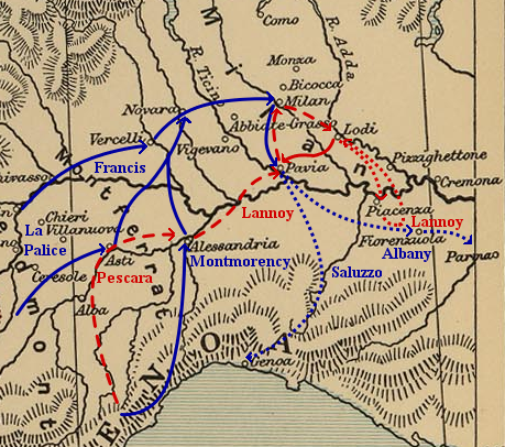
Map of troop movements during the Pavia campaign (1524–25).
|
|---|---|
| Source |
Self-made, based on Image:Frontiers of France (1521).jpg (a map of the eastern frontiers of France for the period 1521–59, from The Cambridge Modern History Atlas (1912) via the Perry-Castañeda Library Map Collection at the University of Texas) and maps found in Angus Konstam's Pavia 1525: The Climax of the Italian Wars (Oxford: Osprey Publishing, 1996). |
| Date |
June 20, 2006 |
| Author | |
| Permission (Reusing this image) |
Public domain as derivative work of a public domain image. |
[edit] Licensing
| I, the copyright holder of this work, hereby release it into the public domain. This applies worldwide. In case this is not legally possible: Afrikaans | Alemannisch | Aragonés | العربية | Asturianu | Български | Català | Česky | Cymraeg | Dansk | Deutsch | Eʋegbe | Ελληνικά | English | Español | Esperanto | Euskara | Estremeñu | فارسی | Français | Galego | 한국어 | हिन्दी | Hrvatski | Ido | Bahasa Indonesia | Íslenska | Italiano | עברית | Kurdî / كوردی | Latina | Lietuvių | Latviešu | Magyar | Македонски | Bahasa Melayu | Nederlands | Norsk (bokmål) | Norsk (nynorsk) | 日本語 | Polski | Português | Ripoarisch | Română | Русский | Shqip | Slovenčina | Slovenščina | Српски / Srpski | Svenska | ไทย | Tagalog | Türkçe | Українська | Tiếng Việt | Walon | 中文(简体) | 中文(繁體) | zh-yue-hant | +/- |
|
|
This media file is in the public domain in the United States. This applies to U.S. works where the copyright has expired, often because its first publication occurred prior to January 1, 1923. See this page for further explanation.
|
|
|
Deutsch | English | Español | Français | Gaeilge | Galego | Italiano | Nederlands | 中文(简体) | +/- |
||
|
|
This image might not be in the public domain outside of the United States (this especially applies in Canada, China (not Hong Kong, Macao, or Taiwan Area), Germany, Mexico, and Switzerland). The creator and year of publication are essential information and must be provided. See Wikipedia:Public domain and Wikipedia:Copyrights for more details. |
Historique du fichier
Cliquer sur une date et une heure pour voir le fichier tel qu’il était à ce moment-là
| Date et heure | Dimensions | Utilisateur | Commentaire | |
|---|---|---|---|---|
| actuel | 20 juin 2006 à 07:22 | 459×406 (401 Kio) | Kirill Lokshin | |
| 20 juin 2006 à 05:26 | 459×406 (359 Kio) | Kirill Lokshin | ({{Information |Description= Map of troop movements during the Pavia campaign (1524–25). |Source= Self-made, based on Image:Frontiers of France (1521).jpg and maps found in Angus Konstam's ''Pavia 1525: The Climax of the Italian Wars'' (Oxford: Ospr) |
Pages contenant l’image
La page ci-dessous contient cette image :


.png)