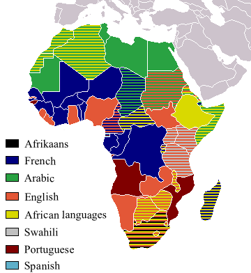
Image:Official LanguagesMap-Africa.png
Un article de Wikipédia, l'encyclopédie libre.
Taille de cet aperçu : 550 × 599 pixels
Image en plus haute résolution (746 × 813 pixels, taille du fichier : 250 Kio, type MIME : image/png)
| | Ce fichier provient de Wikimedia Commons?. Les informations le concernant sont affichées ci-dessous (procédure). |
Taken from Image:BlankMap-Africa.png. Information from http://www.nationsonline.org/oneworld/index.html and CIA World Factbook
| I, the copyright holder of this work, hereby release it into the public domain. This applies worldwide. In case this is not legally possible: Afrikaans | Alemannisch | Aragonés | العربية | Asturianu | Български | Català | Česky | Cymraeg | Dansk | Deutsch | Eʋegbe | Ελληνικά | English | Español | Esperanto | Euskara | Estremeñu | فارسی | Français | Galego | 한국어 | हिन्दी | Hrvatski | Ido | Bahasa Indonesia | Íslenska | Italiano | עברית | Kurdî / كوردی | Latina | Lietuvių | Latviešu | Magyar | Македонски | Bahasa Melayu | Nederlands | Norsk (bokmål) | Norsk (nynorsk) | 日本語 | Polski | Português | Ripoarisch | Română | Русский | Shqip | Slovenčina | Slovenščina | Српски / Srpski | Svenska | ไทย | Tagalog | Türkçe | Українська | Tiếng Việt | Walon | 中文(简体) | 中文(繁體) | zh-yue-hant | +/- |
[edit] Other version
 fr |
Historique du fichier
Cliquer sur une date et une heure pour voir le fichier tel qu’il était à ce moment-là
| Date et heure | Dimensions | Utilisateur | Commentaire | |
|---|---|---|---|---|
| actuel | 6 mai 2008 à 14:54 | 746×813 (250 Kio) | Ant75 | (Updated Madagascar to English, French and Traditional African following 2007 Constitution.) |
| 1 mai 2008 à 14:54 | 720×784 (186 Kio) | Ant75 | (Updated Sudan to English and Arabic following 2005 Constitution.) | |
| 16 mars 2007 à 21:59 | 360×392 (14 Kio) | Rasulo | (Updated earlier version due to officialization of Swahili in Uganda. Also corrected the language status of Zimbabwe where Shona and Ndebele are currently co-official with English.) | |
| 19 mai 2005 à 19:05 | 360×392 (14 Kio) | Rydia | (Taken from Image:BlankMap-Africa.png. Information from http://www.nationsonline.org/oneworld/index.html and CIA World Factbook {{PD}}) |
Pages contenant l’image
Aucune page ne contient cette image.

