Image:Nuclear plants map France.jpg
Un article de Wikipédia, l'encyclopédie libre.
Taille de cet aperçu : 626 × 600 pixels
Image en plus haute résolution (1 200 × 1 150 pixels, taille du fichier : 740 Kio, type MIME : image/jpeg)
| | Ce fichier provient de Wikimedia Commons?. Les informations le concernant sont affichées ci-dessous (procédure). |
[edit] Summary
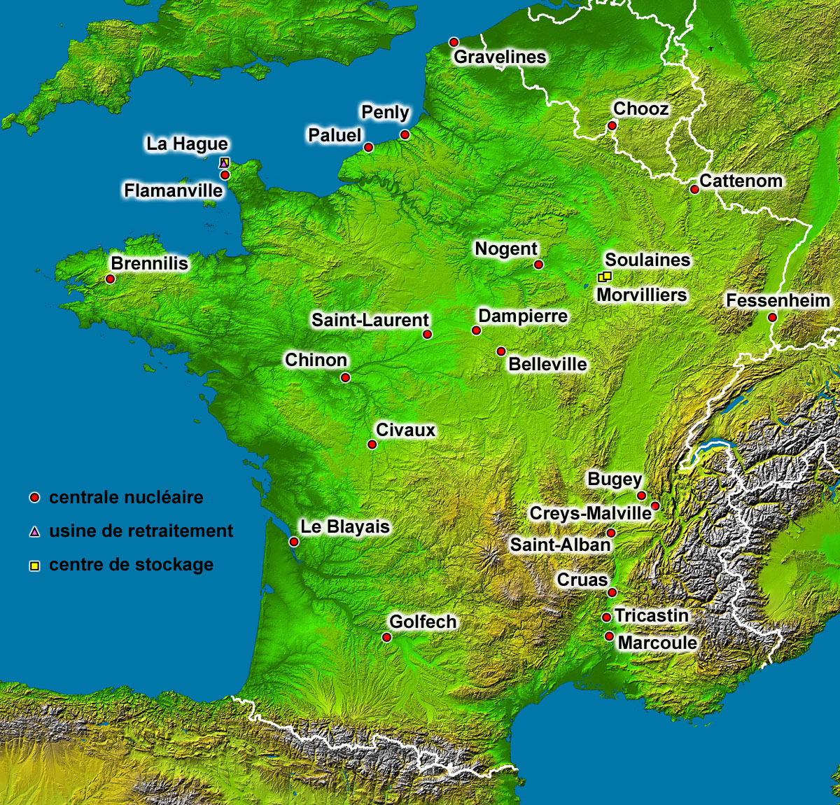
| Description |
Map of the French nuclear power plants (in French) |
|---|---|
| Source |
Background map : Image:France_radar_2.jpg, a modified version from the NASA Earth Observatory |
| Date |
August 2006 |
| Author |
Eric Gaba (Sting) |
| Permission (Reusing this image) |
Public domain |
| Other versions | With two-colours background map : Image:Nuclear_power_plants_map_France-fr.png |
Français :
- Sujet : Carte en français des centrales nucléaires, usines de retraitement et centres de stockage français ;
- Fond de carte : Image:France_radar_2.jpg, une version modifiée du NASA Earth Observatory ;
- Auteur : Eric Gaba (fr:Sting) ;
- Date : Août 2006 ;
- Autre version disponible : Avec fond de carte deux-tons : Image:Nuclear_power_plants_map_France-fr.png.
English: This map was made or improved by the Wikigraphists of the Atelier graphique. You can propose maps or images to clean up and improve as well.
Esperanto: Ĉi tiu mapo estis kreita aŭ plibonigita de la Vikigrafistoj el la Grafika laborgrupo. Vi ankaŭ povas tie proponi mapojn aŭ bildojn plibonigendajn.
Español: Este mapa ha sido confeccionado o mejorado por los Wikígrafos del Taller gráfico. Puedes proponer la mejora de cualquier imagen a través de la página de Peticiones.
Français : Cette carte a été créée ou améliorée par les Wikigraphistes de l'Atelier graphique. Vous pouvez également y proposer des cartes ou des images à améliorer.
Türkçe: Bu harita Atelier graphique'ten Wikigraphistes'ler tarafından yapıldı veya geliştirildi. Siz de haritalar veya resimleri temizlemek veya geliştirmek için teklif edebilirsiniz.
[edit] Licensing
|
|
This file is in the public domain because it was created by NASA. NASA copyright policy states that "NASA material is not protected by copyright unless noted". (NASA copyright policy page or JPL Image Use Policy).
Deutsch | English | Español | Français | Nederlands | Português | Русский | 中文(简体) | 中文(繁體) | +/- |
|
 |
Warnings:
|
| This work was previously under Public Domain, or a Free License. It has been digitally enhanced and/or modified. This derivative work has been (or is hereby) released into the public domain by its author, Sting at the French Wikipedia project. This applies worldwide. In some countries this is not legally possible; if so: |
Historique du fichier
Cliquer sur une date et une heure pour voir le fichier tel qu’il était à ce moment-là
| Date et heure | Dimensions | Utilisateur | Commentaire | |
|---|---|---|---|---|
| actuel | 1 septembre 2006 à 16:35 | 1 200×1 150 (740 Kio) | Sting | (Lightning effect around names enhanced) |
| 30 août 2006 à 07:49 | 1 200×1 150 (709 Kio) | Sting | ({{Information |Description=Map of the French nuclear power plants (in French) |Source=Background map : Image:France_radar_2.jpg, a modified version from the [http://earthobservatory.nasa.gov/Newsroom/NewImages/images.php3?img_id=15360 NASA Earth Obse) |
Pages contenant l’image
Les pages ci-dessous contiennent cette image :
Métadonnées
Ce fichier contient des informations supplémentaires probablement ajoutées par l’appareil photo numérique ou le numériseur qui l’a acquis. Si le fichier a été modifié depuis son état original, certains détails peuvent ne pas refléter entièrement l’image modifiée.
| Description de l’image | converted PNM file |
|---|---|
| Orientation | Normale |
| Résolution horizontale | 72 dpi |
| Résolution verticale | 72 dpi |
| Logiciel utilisé | Adobe Photoshop 7.0 |
| Date de modification | 1 septembre 2006 à 11:29 |
| Espace colorimétrique | 65535 |

