Image:Moghol.jpg
Un article de Wikipédia, l'encyclopédie libre.
Pas de plus haute résolution disponible.
Moghol.jpg (493 × 507 pixels, taille du fichier : 35 Kio, type MIME : image/jpeg)
| | Ce fichier provient de Wikimedia Commons?. Les informations le concernant sont affichées ci-dessous (procédure). |
 |
This map image should be recreated using vector graphics as an SVG file. This has several advantages; see Commons:Media for cleanup for more information. If an SVG form of this image is already available, please upload it. After uploading an SVG, replace this template with template {{Vector version available|new image name.svg}} in this image. |
|
العربية | Български | Català | Česky | Dansk | Deutsch | English | Esperanto | Español | Français | 한국어 | Italiano | Magyar | Lietuvių | Nederlands | 日本語 | Polski | Português | Română | Русский | Suomi | Svenska | Türkçe | Українська | Tiếng Việt | मराठी | 中文(繁體) | 中文(简体) | +/- |
|
| Description |
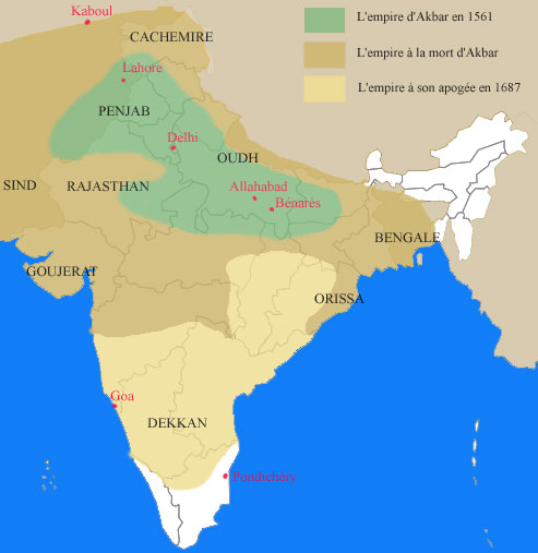
carte de l'expansion moghole en Inde |
|---|---|
| Source |
work by Nataraja |
| Date |
2003-10-31 (first version); 2005-01-26 (last version) |
| Author | |
| Permission (Reusing this image) |
Released under the GNU Free Documentation License. |
| Other versions | Image:Moghol (zh).jpg |
[edit] License information

[edit] Original upload log
(All user names refer to fr.wikipedia)
Historique du fichier
Cliquer sur une date et une heure pour voir le fichier tel qu’il était à ce moment-là
| Date et heure | Dimensions | Utilisateur | Commentaire | |
|---|---|---|---|---|
| actuel | 6 février 2007 à 11:57 | 493×507 (35 Kio) | Bilou | ({{Information |Description=carte de l'expansion moghole en Inde |Source=work by Nataraja |Date=2003-10-31 (first version); 2005-01-26 (last version) |Author=Nataraja at [http://fr.wikipedia.org fr.wikipedia] |Pe) |
Pages contenant l’image
La page ci-dessous contient cette image :

