Image:LocationSouthAfrica-1990.png
Un article de Wikipédia, l'encyclopédie libre.
Pas de plus haute résolution disponible.
LocationSouthAfrica-1990.png (250 × 115 pixels, taille du fichier : 5 Kio, type MIME : image/png)
| | Ce fichier provient de Wikimedia Commons?. Les informations le concernant sont affichées ci-dessous (procédure). |
[edit] Summary
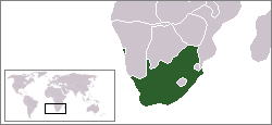
A locator map of South Africa showing en:Walvis Bay. This locator map is intended for South African articles taking place before the transfer of Walvis Bay to Nambia in 1994. The orginal map is by Vardion. Since that map is PD, this one is well.
[edit] Licensing
| This image has been released into the public domain by its author, Hoshie. This applies worldwide. In some countries this may not be legally possible; if so: العربية | Български | Deutsch | Ελληνικά | English | Español | Français | Italiano | 日本語 | 한국어 | Polski | Русский | Српски / Srpski | Svenska | தமிழ் | Українська | 中文(繁體) | 中文(简体) +/- |
Historique du fichier
Cliquer sur une date et une heure pour voir le fichier tel qu’il était à ce moment-là
| Date et heure | Dimensions | Utilisateur | Commentaire | |
|---|---|---|---|---|
| actuel | 16 août 2006 à 05:34 | 250×115 (5 Kio) | Hoshie | (== Summary == A locator map of South Africa showing en:Walvis Bay. This locator map is intended for South African articles taking place before the transfer of Walvis Bay to Nambia in 1994. The orginal map is by [[Us) |
Pages contenant l’image
La page ci-dessous contient cette image :

