Image:Karte eifelwasserleitung.png
Un article de Wikipédia, l'encyclopédie libre.
Taille de cet aperçu : 384 × 600 pixels
Image en plus haute résolution (1 100 × 1 718 pixels, taille du fichier : 200 Kio, type MIME : image/png)
| | Ce fichier provient de Wikimedia Commons?. Les informations le concernant sont affichées ci-dessous (procédure). |
This is a featured picture on German Wikipedia and is considered one of the finest images.
|
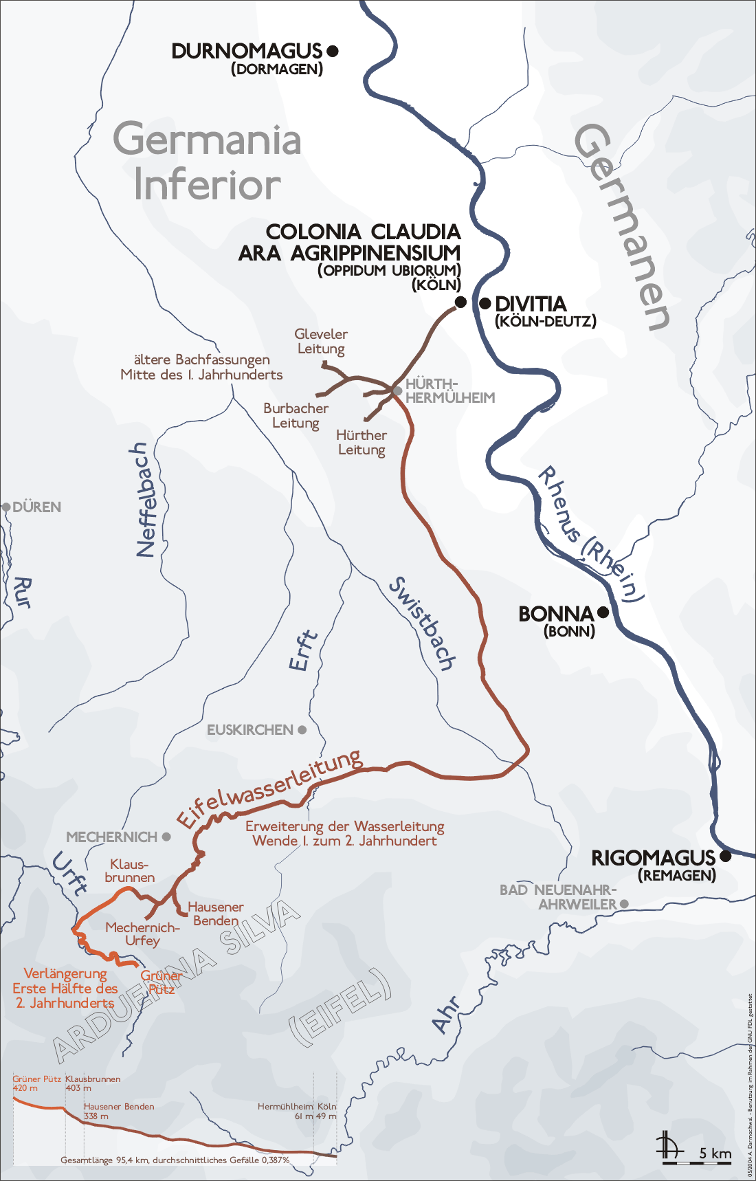
- Description: Map Eifelwasserleitung (Eifel aqueduct, Germany)
- Author:Zeichnung erstellt 2004 von de:Benutzer:Sansculotte
- Licence: This image was released by German wikipedia user Sansculotte under the licence GNU-FDL at the German wikipedia, at the 26th May, 2004, 03:17h. Very good work, although I think the original licencing applies, and can not be changed afterwards. Anyway,
- Please quote source and send an notice to sansculotte@despammed.com.

| This file is licensed under Creative Commons Attribution ShareAlike 2.0 License (cc-by-sa-2.0). In short: you are free to share and make derivative works of the file under the conditions that you appropriately attribute it, and that you distribute it under this or a similar cc-by-sa license. |
[edit] File history German Wikipedia
(Löschen) (Aktuell) 17:39, 12. Sep 2004 . . Sansculotte (204861 Byte) (korr)
(Löschen) (Zurücksetzen) 23:31, 27. Mai 2004 . . Sansculotte (180994 Byte) (upd)
(Löschen) (Zurücksetzen) 23:24, 27. Mai 2004 . . Sansculotte (179720 Byte) (upd)
(Löschen) (Zurücksetzen) 22:29, 26. Mai 2004 . . Sansculotte (165557 Byte) (upd)
(Löschen) (Zurücksetzen) 21:57, 26. Mai 2004 . . Sansculotte (165241 Byte) (update)
(Löschen) (Zurücksetzen) 03:17, 26. Mai 2004 . . Sansculotte (158183 Byte) (eigene Darstellung, GNU FDL, Eifelwasserleitung)
Historique du fichier
Cliquer sur une date et une heure pour voir le fichier tel qu’il était à ce moment-là
| Date et heure | Dimensions | Utilisateur | Commentaire | |
|---|---|---|---|---|
| actuel | 17 septembre 2005 à 12:03 | 1 100×1 718 (200 Kio) | Saperaud | (update from de) |
| 2 juin 2005 à 14:49 | 1 000×1 562 (154 Kio) | Longbow4u | (*'''Description''': Map Eiffelwasserleitung (Eiffel aqueduct, Germany) *'''Author''':Zeichnung erstellt 2004 von Sansculotte *'''Licence''': This image was released by German wikipedia user Sansculotte under the licence GNU-FDL at the German wikipedia, at) |
Pages contenant l’image
La page ci-dessous contient cette image :

