Image:Karte Ukraine.png
Un article de Wikipédia, l'encyclopédie libre.
Taille de cet aperçu : 800 × 559 pixels
Image en plus haute résolution (1 181 × 825 pixels, taille du fichier : 623 Kio, type MIME : image/png)
| | Ce fichier provient de Wikimedia Commons?. Les informations le concernant sont affichées ci-dessous (procédure). |
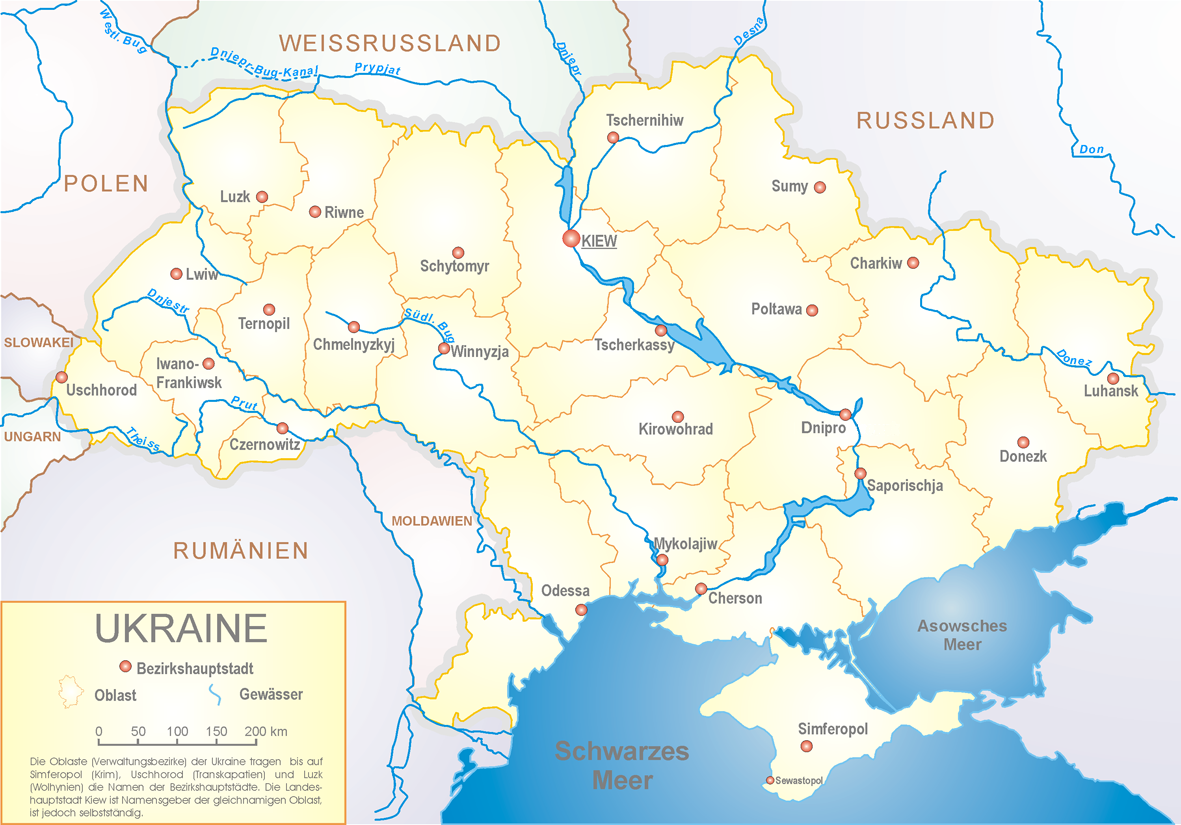
This is a featured picture on German Wikipedia and is considered one of the finest images.
|
Map of ukraine - polish by Sven Teschke
 |
Permission is granted to copy, distribute and/or modify this document under the terms of the GNU Free Documentation License, Version 1.2 only as published by the Free Software Foundation; with no Invariant Sections, no Front-Cover Texts, and no Back-Cover Texts. A copy of the license is included in the section entitled "Text of the GNU Free Documentation License."
العربية | Català | Česky | Deutsch | English | Español | فارسی | Français | Italiano | 日本語 | Nederlands | Norsk (bokmål) | Polski | Português | Русский | Svenska | Türkçe | Tiếng Việt | 中文(简体) | 中文(繁體) | +/- |
|
Das Foto habe ich als Urheber unter der „GFDL – GNU-Lizenz für freie Dokumentation“ in der Wikipedia veröffentlicht. Dies bedeutet, dass eine kostenlose, auch kommerzielle Nutzung außerhalb der Wikimedia-Projekte unter folgenden Bedingungen möglich ist:
Ich bitte um Zusendung eines Belegexemplares bzw. der URL, wo das Foto benutzt wird. Bitte schreiben Sie eine E-Mail an steschke@web.de, wenn Sie
|
|
I have published this image as author under the "GNU Free Documentation License" in Wikipedia. This means that free, commercial usage outside of Wikimedia projects under the following terms of licence is possible:
Please send me a specimen copy or the URL of the website where the image is used. Please write an email to steschke@web.de, if you
|
- english version: Image:Map_of_Ukraine_political_enwiki.png
- polish version: Image:Ukraina map polish.png
- german version: Image:Karte_Ukraine.png
- ukrainian version: uk:Image:Ukraina.png
- Präsidentschaftswahl 04-10-30 Image:Ukraine Wahlen 2004.png
- Präsidentschaftswahl 04-11-21 Image:Ukraine Wahlen 2004 2.png
- Image:Map_of_Ukraine_political_simple blank.png
- Image:Map_of_Ukraine_political_simple_Oblast_Charkiw.png
- Image:Map_of_Ukraine_political_simple_Oblast_Cherson.png
- Image:Map_of_Ukraine_political_simple_Oblast_Chmelnyzkyj.png
- Image:Map_of_Ukraine_political_simple_Oblast_Czernowitz.png
- Image:Map_of_Ukraine_political_simple_Oblast_Dnipropetrowsk.png
- Image:Map_of_Ukraine_political_simple_Oblast_Donezk.png
- Image:Map_of_Ukraine_political_simple_Donbass.png
- Image:Map_of_Ukraine_political_simple_Oblast_Iwano-Frankiwsk.png
- Image:Map_of_Ukraine_political_simple_Oblast_Kiew.png
- Image:Map_of_Ukraine_political_simple_city_Kiew.png
- Image:Map_of_Ukraine_political_simple_Oblast_Kirowohrad.png
- Image:Map_of_Ukraine_political_simple_Oblast_Krim.png
- Image:Map_of_Ukraine_political_simple_Oblast_Lemberg.png
- Image:Map_of_Ukraine_political_simple_Oblast_Luhansk.png
- Image:Map_of_Ukraine_political_simple_Oblast_Mykolajiw.png
- Image:Map_of_Ukraine_political_simple_Oblast_Odessa.png
- Image:Map_of_Ukraine_political_simple_Oblast_Poltawa.png
- Image:Map_of_Ukraine_political_simple_Oblast_Rivne.png
- Image:Map_of_Ukraine_political_simple_Oblast_Saporischja.png
- Image:Map_of_Ukraine_political_simple_Oblast_Schytomyr.png
- Image:Map_of_Ukraine_political_simple_City_Sewastopol.png
- Image:Map_of_Ukraine_political_simple_Oblast_Sumy.png
- Image:Map_of_Ukraine_political_simple_Oblast_Ternopil.png
- Image:Map_of_Ukraine_political_simple_Oblast_Transkarpatien.png
- Image:Map_of_Ukraine_political_simple_Oblast_Tscherkasy.png
- Image:Map_of_Ukraine_political_simple_Oblast_Tschernihiw.png
- Image:Map_of_Ukraine_political_simple_Oblast_Wolhynien.png
- Image:Map_of_Ukraine_political_simple_Oblast_Wynnyzja.png
Historique du fichier
Cliquer sur une date et une heure pour voir le fichier tel qu’il était à ce moment-là
| Date et heure | Dimensions | Utilisateur | Commentaire | |
|---|---|---|---|---|
| actuel | 22 juillet 2005 à 23:17 | 1 181×825 (623 Kio) | Steschke | (Map of ukraine - polish by Sven Teschke {{Maps of Ukraine by Steschke}} {{GFDL}} Category:Maps of Ukraine ) |
Pages contenant l’image
La page ci-dessous contient cette image :

