Image:Hazel.gif
Un article de Wikipédia, l'encyclopédie libre.
Pas de plus haute résolution disponible.
Hazel.gif (312 × 277 pixels, taille du fichier : 32 Kio, type MIME : image/gif)
| | Ce fichier provient de Wikimedia Commons?. Les informations le concernant sont affichées ci-dessous (procédure). |
| Description |
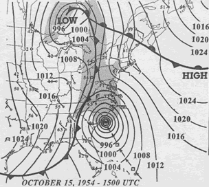
15 UTC map of October 1954 showing Hurricane Hazel and the meteorological set-up. |
|||
|---|---|---|---|---|
| Source |
NOAA analysis put in the text of the Canadian Hurricane Center page on Hazel |
|||
| Date |
2007-04-02 |
|||
| Author |
NOAA |
|||
| Permission (Reusing this image) |
|
Historique du fichier
Cliquer sur une date et une heure pour voir le fichier tel qu’il était à ce moment-là
| Date et heure | Dimensions | Utilisateur | Commentaire | |
|---|---|---|---|---|
| actuel | 2 avril 2007 à 09:23 | 312×277 (32 Kio) | Pierre cb | ({{Hurricane auto track map|type=Hurricane|name=Hazel (1954)|source=NHC}} H {{Information |Description= 15 UTC map of October 1954 showing Hurricane Hazel and the meteorological set-up. |Source= [http://www.atl.e) |
Pages contenant l’image
La page ci-dessous contient cette image :

