Image:Europe in 1430.PNG
Un article de Wikipédia, l'encyclopédie libre.
Taille de cet aperçu : 553 × 599 pixels
Image en plus haute résolution (600 × 650 pixels, taille du fichier : 44 Kio, type MIME : image/png)
| | Ce fichier provient de Wikimedia Commons?. Les informations le concernant sont affichées ci-dessous (procédure). |
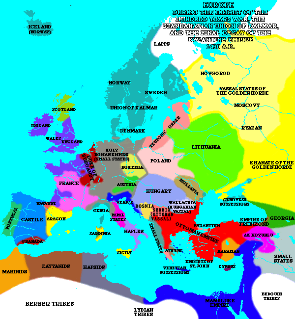
A map of Europe in 1430.
| This file has been (or is hereby) released into the public domain by its author, Lynn H. Nelson. This applies worldwide.
In case this is not legally possible: العربية | Български | Česky | Dansk | Deutsch | Ελληνικά | English | Español | فارسی | Français | Italiano | 日本語 | Nederlands | Polski | Português | Русский | Svenska | Türkçe | Українська | 中文 | 中文(台灣) | +/- |
Source:[1]
| Maps of the history of Europe | |
| BC aC |
|
|
|
|
| AD dC |
60 · 395 · 400 · 450 · 476 · 526 · 526-600 · 800 · 814 · 843-870 · 998 · 1000 · 1092 · 1097 · 1142 · 1190 · 1328 · 1360 · C.15 · 1430 · 1470 · 1490 · 1550 · 1648 · 1700 · 1708 · 1740 · 1812 · 1814 · 1815 · 1890 · 1905 · 1911 · 1914-24 · 1919-29 · 1941-42 · 1942-45 · 1945-89 · 1993-2006 · 2006 to date |
| (this template: · view · discuss ) | |
Historique du fichier
Cliquer sur une date et une heure pour voir le fichier tel qu’il était à ce moment-là
| Date et heure | Dimensions | Utilisateur | Commentaire | |
|---|---|---|---|---|
| actuel | 8 mars 2005 à 21:30 | 600×650 (44 Kio) | Quadell | (A map of Europe in 1430.{{PD}}Source:[http://www.ku.edu/kansas/medieval/108/lectures/]Category:Maps of EuropeCategory:Historical mapsCategory:1430) |
Pages contenant l’image
Les pages ci-dessous contiennent cette image :

