Image:EUROPE 1919-1929 POLITICAL 01.png
Un article de Wikipédia, l'encyclopédie libre.
Taille de cet aperçu : 642 × 599 pixels
Image en plus haute résolution (857 × 800 pixels, taille du fichier : 96 Kio, type MIME : image/png)
| | Ce fichier provient de Wikimedia Commons?. Les informations le concernant sont affichées ci-dessous (procédure). |
[edit] Summary
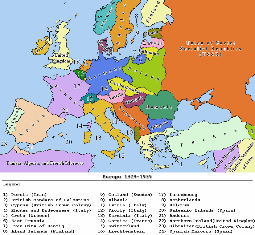
| Description |
Political map of Europe between the years 1929 and 1939 |
|---|---|
| Source |
own work |
| Date |
December 27, 2006 |
| Author |
Jan Humpolík |
| Permission (Reusing this image) |
GNU |
| Other versions | N/A |
| Maps of the history of Europe | |
| BC aC |
|
|
|
|
| AD dC |
60 · 395 · 400 · 450 · 476 · 526 · 526-600 · 800 · 814 · 843-870 · 998 · 1000 · 1092 · 1097 · 1142 · 1190 · 1328 · 1360 · C.15 · 1430 · 1470 · 1490 · 1550 · 1648 · 1700 · 1708 · 1740 · 1812 · 1814 · 1815 · 1890 · 1905 · 1911 · 1914-24 · 1919-29 · 1941-42 · 1942-45 · 1945-89 · 1993-2006 · 2006 to date |
| (this template: · view · discuss ) | |
 |
This map image should be recreated using vector graphics as an SVG file. This has several advantages; see Commons:Media for cleanup for more information. If an SVG form of this image is already available, please upload it. After uploading an SVG, replace this template with template {{Vector version available|new image name.svg}} in this image. |
|
العربية | Български | Català | Česky | Dansk | Deutsch | English | Esperanto | Español | Français | 한국어 | Italiano | Magyar | Lietuvių | Nederlands | 日本語 | Polski | Português | Română | Русский | Suomi | Svenska | Türkçe | Українська | Tiếng Việt | मराठी | 中文(繁體) | 中文(简体) | +/- |
|
[edit] Licensing

Historique du fichier
Cliquer sur une date et une heure pour voir le fichier tel qu’il était à ce moment-là
| Date et heure | Dimensions | Utilisateur | Commentaire | |
|---|---|---|---|---|
| actuel | 29 février 2008 à 09:53 | 857×800 (96 Kio) | Hoshie | (fixed the legend) |
| 27 décembre 2006 à 21:34 | 857×800 (113 Kio) | JanhumpoliK | ({{Information |Description=Political map of Europe between the years 1929 and 1939 |Source=own work |Date=December 27, 2006 |Author=Jan Humpolík |Permission=GNU |other_versions=N/A }}) |
Pages contenant l’image
Les pages ci-dessous contiennent cette image :

