Image:East-Hem 565ad.jpg
Un article de Wikipédia, l'encyclopédie libre.
Taille de cet aperçu : 800 × 470 pixels
Image en plus haute résolution (3 240 × 1 903 pixels, taille du fichier : 760 Kio, type MIME : image/jpeg)
| | Ce fichier provient de Wikimedia Commons?. Les informations le concernant sont affichées ci-dessous (procédure). |
| Description |
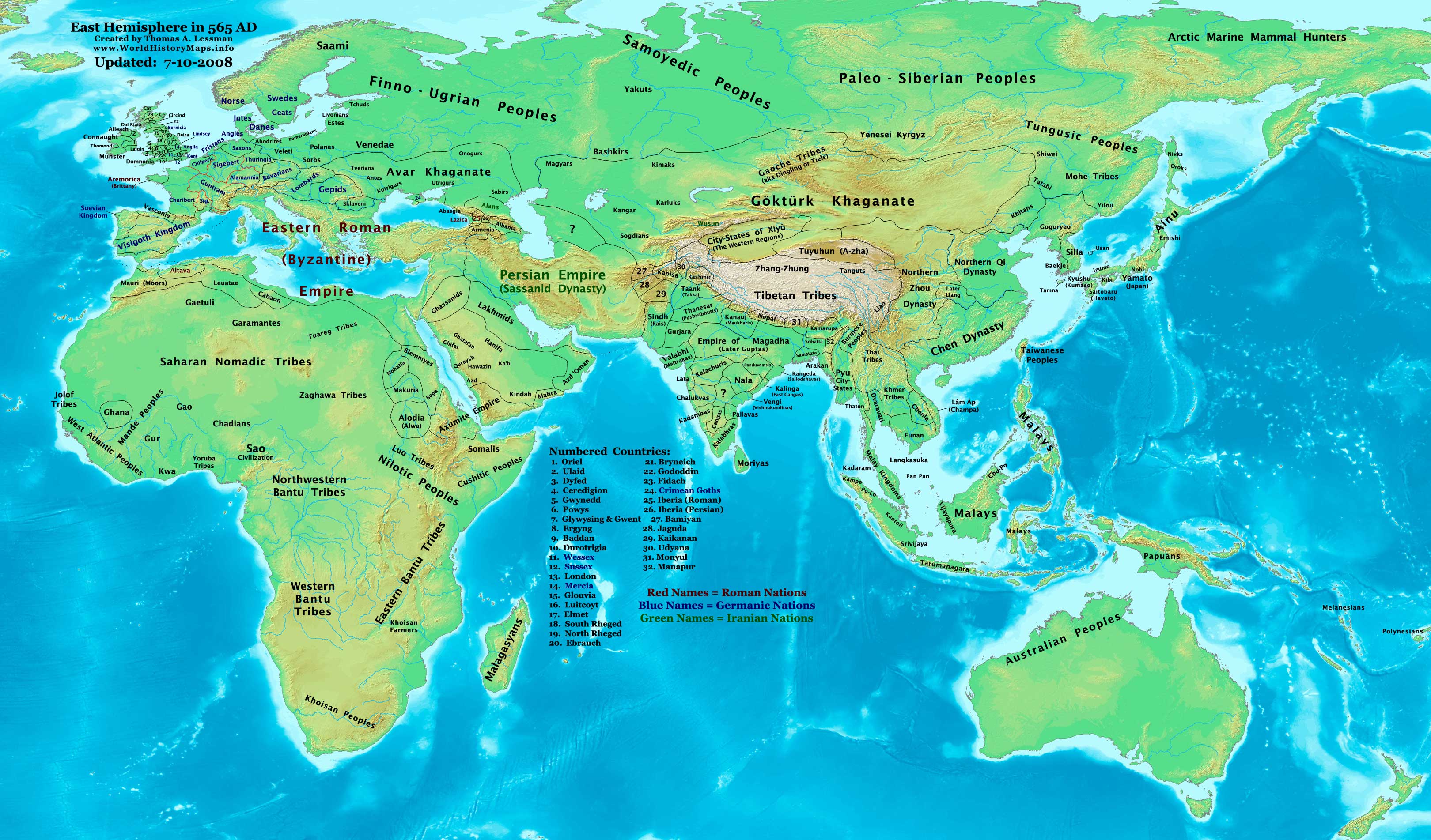
Eastern Hemisphere in 565 AD. |
|||
|---|---|---|---|---|
| Source |
self-made (For reference information, see the Map Source References section below.) |
|||
| Date | ||||
| Author | ||||
| Permission (Reusing this image) |
|
|||
| Other versions | see East-Hem_565ad.jpg file history on Wikipedia. |
[edit] Map Summary
Original Source URL: http://www.thomaslessman.com/History/images/East-Hem_565ad.jpg.
This map of the Eastern Hemisphere in 565 AD was created by Thomas Lessman, based on information from the sources listed below. This map is free for educational use (see Permission info above). When using this map, please mention that it is available for free at www.WorldHistoryMaps.info.
[edit] Map Source References
- Remember, sources often conflict with each other. This map is only as accurate as the information that is available to me. To report any errors or to help further this work, please click here, or email Thomas Lessman at talessman@yis.us
References for information contained in this map:
1. Borders of Europe are mostly derived from the www.Euratlas.com map of Europe in 600 AD and to a lesser extent, their map of Europe in 500 AD.
- (Please note: User:Bogomolov.PL has done a great job of showing me possible discrepancies in my north European borders compared to this source, due to the differences in the geographical layout of the maps.)
2. Borders of Britain derived from "Early British Kingdoms" map of Britain in 550 AD and their map of Britain in 575 AD.
3. Borders of Asian countries are mostly derived from the Huhai.net maps of Asia in 500 AD and Asia in 610 AD.
- Other Asian information came from Wikipedia articles related to countries and peoples depicted in this map.
4. Fringe areas like Africa, Australia, Siberia, etc. are partially derived from Wikimedia's map of The_world_in_500_CE, created by User:Javierfv1212.
5. Much of the information in this map was cross-checked with Bruce Gordon's Regnal Chronologies.
[edit] Other Maps by Thomas Lessman
| World History Maps showing history of the World or Eastern Hemisphere.
Bold dates are available on Wikimedia or Wikipedia. |
||
| Primeval | ||
| Ancient
|
·| 600 BC | 550 BC | 527 BC | 500 BC | 400 BC | ·| 001 AD | 050 AD | 100 AD | 200 AD | 300 AD | |
|
| Medieval |
·| 500 AD | 525 AD | 565 AD | 600 AD | 700 AD | |
|
| Modern |
·| 1500 AD | · * For more maps after 1500 AD (and before), |
|
| (This template: · view · discuss ) | ||
Historique du fichier
Cliquer sur une date et une heure pour voir le fichier tel qu’il était à ce moment-là
| Date et heure | Dimensions | Utilisateur | Commentaire | |
|---|---|---|---|---|
| actuel | 9 mai 2008 à 23:18 | 3 240×1 903 (760 Kio) | Talessman | ({{Information |Description=Eastern Hemisphere in 565 AD. |Source=self-made |Author=Thomas Lessman |Permission={{self|cc-by-sa-3.0}} }}) |
Pages contenant l’image
La page ci-dessous contient cette image :

