Image:Dalriada.jpg
Un article de Wikipédia, l'encyclopédie libre.
Pas de plus haute résolution disponible.
Dalriada.jpg (509 × 531 pixels, taille du fichier : 34 Kio, type MIME : image/jpeg)
| | Ce fichier provient de Wikimedia Commons?. Les informations le concernant sont affichées ci-dessous (procédure). |
[edit] Summary
| Description |
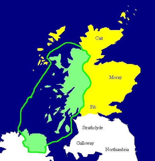
English: Extent of the Kingdom of Dál Riata (in green), c. AD 590. Yellow areas show occupation by the Picts.
Español: Mapa de Dalriada hacia el año 590. Las regiones pictas están marcadas en amarillo.
|
|---|---|
| Source |
Copied from en:Image:Dalriada.jpg. |
| Date | |
| Author | |
| Permission (Reusing this image) |
see below |
[edit] Licensing
| This image has been released into the public domain by its author, Briangotts. This applies worldwide. In some countries this may not be legally possible; if so: العربية | Български | Deutsch | Ελληνικά | English | Español | Français | Italiano | 日本語 | 한국어 | Polski | Русский | Српски / Srpski | Svenska | தமிழ் | Українська | 中文(繁體) | 中文(简体) +/- |
Historique du fichier
Cliquer sur une date et une heure pour voir le fichier tel qu’il était à ce moment-là
| Date et heure | Dimensions | Utilisateur | Commentaire | |
|---|---|---|---|---|
| actuel | 27 septembre 2005 à 17:49 | 509×531 (34 Kio) | R | (Copied from en:Image:Dalriada.jpg. Author: en:User:Briangotts. Extent of the Kingdom of Dalriada (in green), c.590 CE. Yellow areas show occupation by the Picts. {{PD}} ) |
Pages contenant l’image
La page ci-dessous contient cette image :

