Image:Cameroon boundary changes.PNG
Un article de Wikipédia, l'encyclopédie libre.
Taille de cet aperçu : 710 × 600 pixels
Image en plus haute résolution (2 000 × 1 689 pixels, taille du fichier : 170 Kio, type MIME : image/png)
| | Ce fichier provient de Wikimedia Commons?. Les informations le concernant sont affichées ci-dessous (procédure). |
[edit] Summary
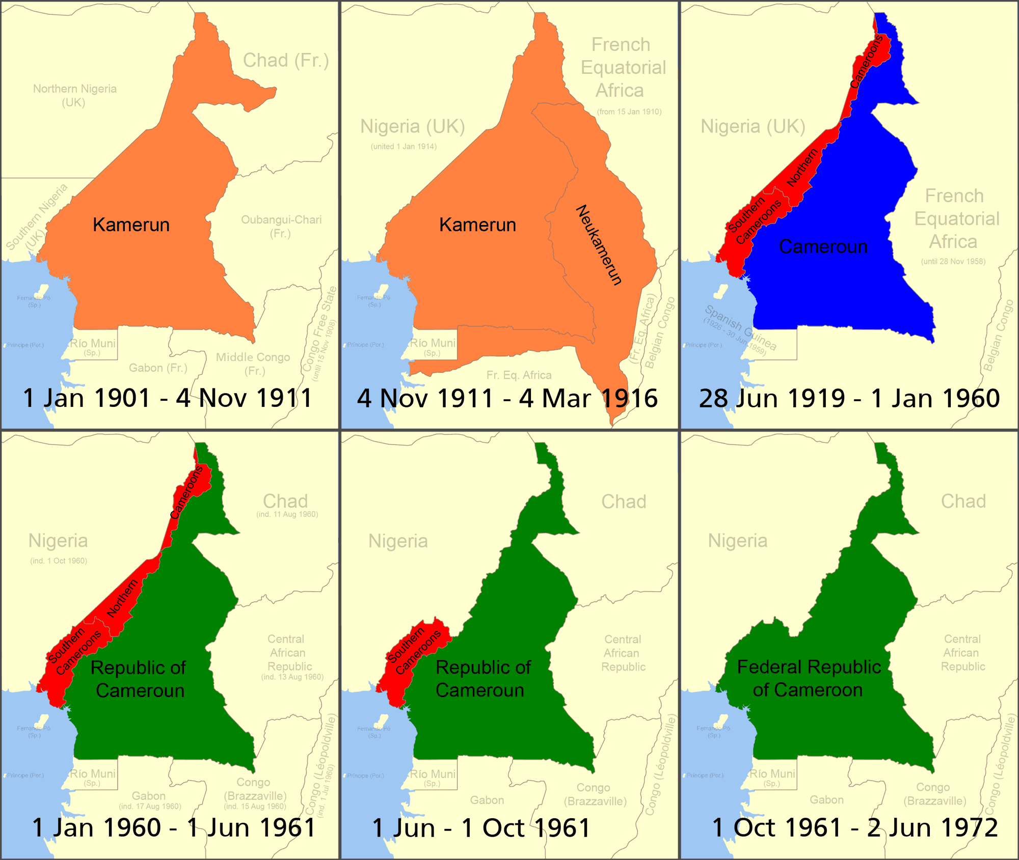
Boundary changes in Cameroon.
██ German colony of Kamerun ![]() - Protectorate from 1884, German West Africa until 1891, German North-west Africa until 1901, when renamed Kamerun. Ceded territory by France on 4 Nov. 1911 following the Agadir Crisis which becomes Neukamerun, while a small amount of territory east of the Logone River (now Chad) was ceded to French Equatorial Africa from Kamerun. Invaded by the allies in 1914 during WWI, final surrender of Germans in Cameroon 4 Mar 1916, occupied by allies, formally becomes League of Nations Mandates 28 Jun, 1919.
- Protectorate from 1884, German West Africa until 1891, German North-west Africa until 1901, when renamed Kamerun. Ceded territory by France on 4 Nov. 1911 following the Agadir Crisis which becomes Neukamerun, while a small amount of territory east of the Logone River (now Chad) was ceded to French Equatorial Africa from Kamerun. Invaded by the allies in 1914 during WWI, final surrender of Germans in Cameroon 4 Mar 1916, occupied by allies, formally becomes League of Nations Mandates 28 Jun, 1919.
██ British Cameroons ![]() League of Nations mandate from 1919, (divided into separate Northern Cameroons and Southern Cameroons - Northern Cameroons consisted of two non-contiguous sections. Northern Cameroons administered as territory of Nigeria, Southern Cameroons as a separate province of Nigeria. UN trust territory after 13 Dec 1946. Becomes an autonomous part of the colony of Nigeria, 1 Oct 1954. Northern Cameroons joins with Nigeria 1 Jun 1961. Southern Cameroons becomes part of Cameroon, 1 Oct. 1961.
League of Nations mandate from 1919, (divided into separate Northern Cameroons and Southern Cameroons - Northern Cameroons consisted of two non-contiguous sections. Northern Cameroons administered as territory of Nigeria, Southern Cameroons as a separate province of Nigeria. UN trust territory after 13 Dec 1946. Becomes an autonomous part of the colony of Nigeria, 1 Oct 1954. Northern Cameroons joins with Nigeria 1 Jun 1961. Southern Cameroons becomes part of Cameroon, 1 Oct. 1961.
██ French Cameroun![]() . Originally League of Nations mandate from 1919, UN trust territory after 13 Dec 1946.
. Originally League of Nations mandate from 1919, UN trust territory after 13 Dec 1946.
██ Independent Cameroon ![]() ; Republic of Cameroon on 1 Jan 1960, becomes Federal Republic of Cameroon after joining with "Southern Cameroons" 1 Oct. 1961. Renamed to United Republic of Cameroon 2 Jun 1972.
; Republic of Cameroon on 1 Jan 1960, becomes Federal Republic of Cameroon after joining with "Southern Cameroons" 1 Oct. 1961. Renamed to United Republic of Cameroon 2 Jun 1972.
self made based on public domain CIA map Image:Cameroon Map.jpg, original svg file located here.
[edit] Reference
- German Cameroons 1914
- World Statesman, Cameroon
- Image:Southern cameroons.PNG - map of southern cameroons
- cameroon
- Kamerun 1912
- British Cameroons
[edit] Licensing

Historique du fichier
Cliquer sur une date et une heure pour voir le fichier tel qu’il était à ce moment-là
| Date et heure | Dimensions | Utilisateur | Commentaire | |
|---|---|---|---|---|
| actuel | 18 juillet 2007 à 13:54 | 2 000×1 689 (170 Kio) | Roke | (more detailed) |
| 11 juillet 2006 à 11:19 | 508×680 (18 Kio) | Roke | (Boundary changes in w:Cameroon. *Orange = German colony of Kamerun *Red = British w:Cameroons after WWI (divided into separate Northern Cameroons and Southern Cameroons) *Blue = French Cameroun after WWI *Green = Independent Cameroon ("Northern Ca) |
Pages contenant l’image
Les pages ci-dessous contiennent cette image :

