Image:Ardf map.png
Un article de Wikipédia, l'encyclopédie libre.
Pas de plus haute résolution disponible.
Ardf_map.png (600 × 550 pixels, taille du fichier : 430 Kio, type MIME : image/png)
| | Ce fichier provient de Wikimedia Commons?. Les informations le concernant sont affichées ci-dessous (procédure). |
Contents |
[edit] source/author
[edit] Description
[edit] Summary
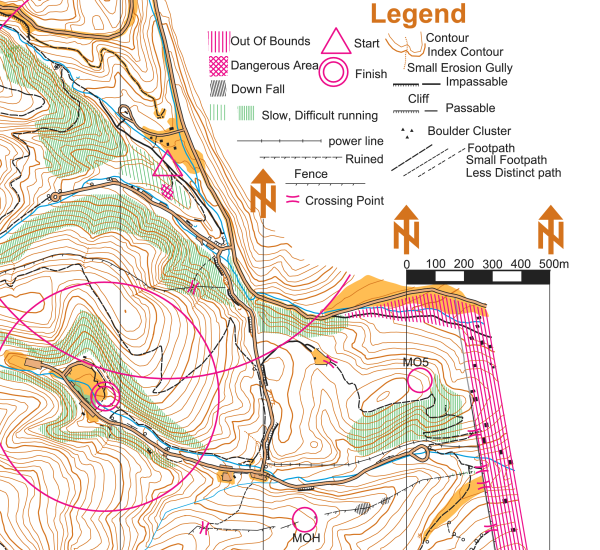
On this portion of an ARDF map, the start location is indicated by a triangle and the finish location is indicated by two concentric circles. The locations of two of the five transmitters are indicated on this version of the map with circles and the labels MOH and MO5 - on the versions of the map given to competitors, the locations of the transmitters are not indicated.
This map is a portion of the Cibola National Forest in the Sandia Mountains east of Albuquerque, New Mexico. The map was used for the eighty meter competition of the Third IARU Region II ARDF Championship, August 5, 2005. This map is not created to the International Orienteering Federation standards for orienteering maps.
The map was created in 2005 by Jerry Boyd of Albuquerque, New Mexico, with field checking by Gail Boyd, Taylor Boyd, Jack Stump, Scott Stevenson, and Jerry Boyd. Contact information for these individuals is available at the Albuquerque Transmitter Hunters web site. This image of the map has been released under GFDL by its author, Jerry Boyd, and is used with permission.
A subsequent map of the same terrain has been created from scratch by professional mapmakers working on behalf of New Mexico Orienteers. Work on that map began in 2005, after the completion of the 2005 IARU Region II ARDF Championship.
[edit] Licensing
 |
Permission is granted to copy, distribute and/or modify this document under the terms of the GNU Free Documentation License, Version 1.2 or any later version published by the Free Software Foundation; with no Invariant Sections, no Front-Cover Texts, and no Back-Cover Texts. Subject to disclaimers. Asturianu | Български | Català | Deutsch | English | Español | Français | Gaeilge | Italiano | 한국어 | 日本語 | Polski | Português | Română | Türkçe | +/- |
Historique du fichier
Cliquer sur une date et une heure pour voir le fichier tel qu’il était à ce moment-là
| Date et heure | Dimensions | Utilisateur | Commentaire | |
|---|---|---|---|---|
| actuel | 12 mars 2006 à 22:46 | 600×550 (430 Kio) | Greudin | (== Summary == On this portion of an ARDF map, the start location is indicated by a triangle and the finish location is indicated by two concentric circles. The locations of two of the five transmitters are indicated on ) |
Pages contenant l’image
La page ci-dessous contient cette image :

