Image:Amazonie deforestation.jpg
Un article de Wikipédia, l'encyclopédie libre.
Taille de cet aperçu : 755 × 600 pixels
Image en plus haute résolution (778 × 618 pixels, taille du fichier : 398 Kio, type MIME : image/jpeg)
| | Ce fichier provient de Wikimedia Commons?. Les informations le concernant sont affichées ci-dessous (procédure). |
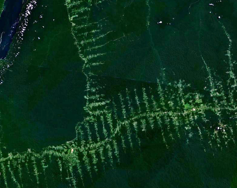
[edit] Description
English: Deforestation in Amazonia, seen from satellite. The roads in the forest follow a typical "fishbone" pattern
Français : Déforestation en Amazonie, vu depuis un satellite. Les routes tracées dans la forêt suivent un motif caractéristique similaire à des arêtes de poisson
[edit] Licensing
|
|
This file is in the public domain because it was created by NASA. NASA copyright policy states that "NASA material is not protected by copyright unless noted". (NASA copyright policy page or JPL Image Use Policy).
Deutsch | English | Español | Français | Nederlands | Português | Русский | 中文(简体) | 中文(繁體) | +/- |
|
 |
Warnings:
|
Historique du fichier
Cliquer sur une date et une heure pour voir le fichier tel qu’il était à ce moment-là
| Date et heure | Dimensions | Utilisateur | Commentaire | |
|---|---|---|---|---|
| actuel | 20 septembre 2006 à 22:02 | 778×618 (398 Kio) | Dake | ({{en|Deforestation in Amazonia, seen from satellite. The roads in the forest follow a typical "fishbone" pattern}} {{fr|Déforestation en Amazonie, vu depuis un satellite. Les routes tracées dans la forêt suivent un motif caractéristique similaire à ) |
Pages contenant l’image
La page ci-dessous contient cette image :
Métadonnées
Ce fichier contient des informations supplémentaires probablement ajoutées par l’appareil photo numérique ou le numériseur qui l’a acquis. Si le fichier a été modifié depuis son état original, certains détails peuvent ne pas refléter entièrement l’image modifiée.
| Orientation | Normale |
|---|---|
| Résolution horizontale | 72 dpi |
| Résolution verticale | 72 dpi |
| Logiciel utilisé | Adobe Photoshop CS2 Windows |
| Date de modification | 20 septembre 2006 à 21:59 |
| Espace colorimétrique | 65535 |

